Wallerfing geodata
Wallerfing (Bavaria) is a seat of a fourth-order administrative division; located in Germany in Europe/Berlin (GMT+2) time zone. With population of 1,388 people, there are 6101 cities with bigger population in this country. Compared to other cities in Germany, 86.7% of cities are located further ↑North; 91.3% of cities are located further ←West and 70.1% of cities have lower elevation than Wallerfing. Note1
Administrative division(s):
- Level 1: Bavaria
- Level 2: Lower Bavaria
- Level 3: Landkreis Deggendorf
- Level 4: Wallerfing


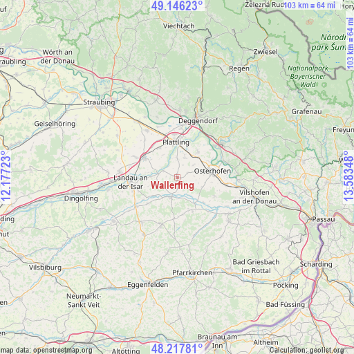
Wallerfing GPS coordinates[2]
48° 41' 2.976" North, 12° 52' 49.26" East
| Map corner | latitude | longitude |
|---|---|---|
| Upper-left | 49.14623°, | 12.17723° |
| Center: | 48.68416°, | 12.88035° |
| Lower-right: | 48.21781°, | 13.58348° |
| Map W x H: | 103.2×103.2 km | = 64.1×64.1mi |
| max Lat: | 55.01917° ⇑86.7% North |
| Wallerfing: | 48.68416° |
| min Lat: | ⇓13.3% South 47.40724° |
| min Long | Wallerfing | max Long |
| 5.92978° | 12.88035° | 14.98853° |
| W 91.3%⇐ | ⇒8.7% E |
Elevation
Elevation of Wallerfing is 359 m = 1178 ft, and this is 109.9 m = 361 ft above average elevation for this country.
| Max E: |
1256 m = 4121 ft | 29.9% |
| Wallerfing | 359 m 1178 ft | |
| Avg. | 249.1 m = 817 ft | |
Min E: |
-5 m = -16 ft | 70.1% |
See also: Germany elevation on elevation.city.
Geographical zone
Wallerfing is located in North temperate zone (between Tropic of Cancer and the Arctic Circle). Distance of this North polar circle is 1988 km =1235.3 mi to North.| Distance of | km | miles | from Wallerfing |
|---|---|---|---|
| North Pole | 4593.9 | 2854.5 | to North |
| Arctic Circle | 1988 | 1235.3 | to North |
| Tropic Cancer | 2807.3 | 1744.4 | to South |
| Equator | 5413.2 | 3363.6 | to South |


Nearby cities:
15 places around Wallerfing: (largest is in red/bold)
• Aholming
6.1 km =3.8 mi,  20°
20°
• Arnstorf
14.7 km =9.1 mi,  198°
198°
• Buchhofen
3.5 km =2.2 mi,  66°
66°
• Eichendorf
6 km =3.7 mi, 197°
• Künzing
15 km =9.3 mi,  97°
97°
• Landau an der Isar
13.8 km =8.6 mi,  264°
264°
• Moos
9.5 km =5.9 mi,  38°
38°
• Niederalteich
13.9 km =8.6 mi,  49°
49°
• Oberpöring
4.5 km =2.8 mi,  295°
295°
• Osterhofen
10.6 km =6.6 mi,  80°
80°
• Otzing
10.1 km =6.3 mi,  328°
328°
• Plattling
10.5 km =6.5 mi,  357°
357°
• Rossbach
12.3 km =7.6 mi,  155°
155°
• Roßbach
10.1 km =6.3 mi, 157°
• Wallersdorf
11.4 km =7.1 mi, 301°
Sources, notices
• [Note1] Compared only with cities in Germany existing in our database
• [Src1] Map data: © OpenStreetMap contributors (CC-BY-SA)
• [Src2] Other city data from geonames.org with taken over terms of usage.
• [Src3] Geographical zone / Annual Mean Temperature by Robert A. Rohde @ Wikipedia
