Eichendorf geodata
Eichendorf (Bavaria) is a populated place; located in Germany in Europe/Berlin (GMT+2) time zone. With population of 6,617 people, there are 2276 cities with bigger population in this country. Compared to other cities in Germany, 87.4% of cities are located further ↑North; 91.2% of cities are located further ←West and 70% of cities have lower elevation than Eichendorf. Note1
Administrative division(s):
- Level 1: Bavaria
- Level 2: Lower Bavaria
- Level 3: Landkreis Dingolfing-Landau
- Level 4: Eichendorf, Markt


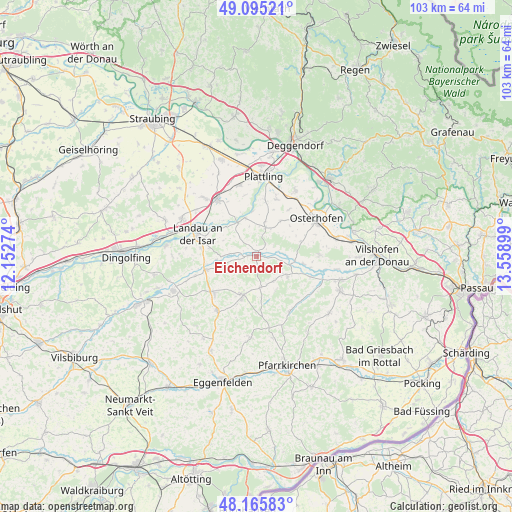
Eichendorf GPS coordinates[2]
48° 37' 57.576" North, 12° 51' 21.096" East
| Map corner | latitude | longitude |
|---|---|---|
| Upper-left | 49.09521°, | 12.15274° |
| Center: | 48.63266°, | 12.85586° |
| Lower-right: | 48.16583°, | 13.55899° |
| Map W x H: | 103.3×103.3 km | = 64.2×64.2mi |
| max Lat: | 55.01917° ⇑87.4% North |
| Eichendorf: | 48.63266° |
| min Lat: | ⇓12.6% South 47.40724° |
| min Long | Eichendorf | max Long |
| 5.92978° | 12.85586° | 14.98853° |
| W 91.2%⇐ | ⇒8.8% E |
Elevation
Elevation of Eichendorf is 358 m = 1175 ft, and this is 108.9 m = 357 ft above average elevation for this country.
| Max E: |
1256 m = 4121 ft | 30% |
| Eichendorf | 358 m 1175 ft | |
| Avg. | 249.1 m = 817 ft | |
Min E: |
-5 m = -16 ft | 70% |
See also: Germany elevation on elevation.city.
Geographical zone
Eichendorf is located in North temperate zone (between Tropic of Cancer and the Arctic Circle). Distance of this North polar circle is 1993.7 km =1238.8 mi to North.| Distance of | km | miles | from Eichendorf |
|---|---|---|---|
| North Pole | 4599.6 | 2858.1 | to North |
| Arctic Circle | 1993.7 | 1238.8 | to North |
| Tropic Cancer | 2801.5 | 1740.8 | to South |
| Equator | 5407.4 | 3360 | to South |


Nearby cities:
15 places around Eichendorf: (largest is in red/bold)
• Aholming
12.1 km =7.5 mi,  19°
19°
• Arnstorf
8.7 km =5.4 mi,  199°
199°
• Buchhofen
8.8 km =5.5 mi,  35°
35°
• Haibach
14.4 km =8.9 mi,  137°
137°
• Johanniskirchen
13 km =8.1 mi,  147°
147°
• Landau an der Isar
12.7 km =7.9 mi,  290°
290°
• Malgersdorf
13.5 km =8.4 mi,  215°
215°
• Oberpöring
8 km =5 mi,  343°
343°
• Osterhofen
14.3 km =8.9 mi,  58°
58°
• Otzing
14.7 km =9.1 mi,  346°
346°
• Rossbach
8.8 km =5.5 mi,  128°
128°
• Roßbach
6.8 km =4.2 mi,  122°
122°
• Simbach
11.4 km =7.1 mi,  229°
229°
• Wallerfing
6 km =3.7 mi, 17°
• Wallersdorf
14.1 km =8.8 mi,  325°
325°
Sources, notices
• [Note1] Compared only with cities in Germany existing in our database
• [Src1] Map data: © OpenStreetMap contributors (CC-BY-SA)
• [Src2] Other city data from geonames.org with taken over terms of usage.
• [Src3] Geographical zone / Annual Mean Temperature by Robert A. Rohde @ Wikipedia
