Schönau geodata
Schönau (Bavaria) is a seat of a fourth-order administrative division; located in Germany in Europe/Berlin (GMT+2) time zone. With population of 2,058 people, there are 4987 cities with bigger population in this country. Compared to other cities in Germany, 89.3% of cities are located further ↑North; 91.1% of cities are located further ←West and 81% of cities have lower elevation than Schönau. Note1
Administrative division(s):
- Level 1: Bavaria
- Level 2: Lower Bavaria
- Level 3: Landkreis Rottal-Inn
- Level 4: Schönau


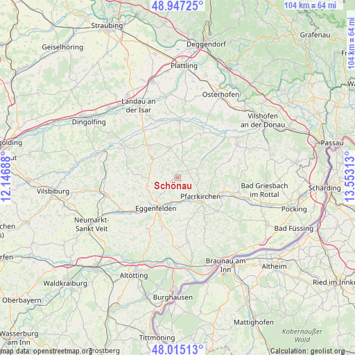
Schönau GPS coordinates[2]
48° 28' 59.988" North, 12° 51' 0" East
| Map corner | latitude | longitude |
|---|---|---|
| Upper-left | 48.94725°, | 12.14688° |
| Center: | 48.48333°, | 12.85° |
| Lower-right: | 48.01513°, | 13.55313° |
| Map W x H: | 103.6×103.6 km | = 64.4×64.4mi |
| max Lat: | 55.01917° ⇑89.3% North |
| Schönau: | 48.48333° |
| min Lat: | ⇓10.7% South 47.40724° |
| min Long | Schönau | max Long |
| 5.92978° | 12.85° | 14.98853° |
| W 91.1%⇐ | ⇒8.9% E |
Elevation
Elevation of Schönau is 440 m = 1444 ft, and this is 190.9 m = 626 ft above average elevation for this country.
| Max E: |
1256 m = 4121 ft | 19% |
| Schönau | 440 m 1444 ft | |
| Avg. | 249.1 m = 817 ft | |
Min E: |
-5 m = -16 ft | 81% |
See also: Germany elevation on elevation.city.
Geographical zone
Schönau is located in North temperate zone (between Tropic of Cancer and the Arctic Circle). Distance of this North polar circle is 2010.3 km =1249.1 mi to North.| Distance of | km | miles | from Schönau |
|---|---|---|---|
| North Pole | 4616.2 | 2868.4 | to North |
| Arctic Circle | 2010.3 | 1249.1 | to North |
| Tropic Cancer | 2784.9 | 1730.5 | to South |
| Equator | 5390.8 | 3349.7 | to South |


Nearby cities:
15 places around Schönau: (largest is in red/bold)
• Arnstorf
8.7 km =5.4 mi,  343°
343°
• Dietersburg
5.6 km =3.5 mi,  79°
79°
• Eggenfelden
11.1 km =6.9 mi,  218°
218°
• Falkenberg
9.1 km =5.7 mi,  254°
254°
• Haibach
11.7 km =7.3 mi,  59°
59°
• Hebertsfelden
8.8 km =5.5 mi,  193°
193°
• Johanniskirchen
9.2 km =5.7 mi,  52°
52°
• Malgersdorf
9.2 km =5.7 mi,  307°
307°
• Pfarrkirchen
8.6 km =5.3 mi,  131°
131°
• Postmünster
8.3 km =5.2 mi,  153°
153°
• Rimbach
14.9 km =9.3 mi,  262°
262°
• Rossbach
13.3 km =8.3 mi,  33°
33°
• Roßbach
14.3 km =8.9 mi, 25°
• Ruhstorf
13.8 km =8.6 mi,  297°
297°
• Simbach
12.3 km =7.6 mi,  318°
318°
Sources, notices
• [Note1] Compared only with cities in Germany existing in our database
• [Src1] Map data: © OpenStreetMap contributors (CC-BY-SA)
• [Src2] Other city data from geonames.org with taken over terms of usage.
• [Src3] Geographical zone / Annual Mean Temperature by Robert A. Rohde @ Wikipedia
