Ulrichstein geodata
Ulrichstein (Hesse) is a populated place; located in Germany in Europe/Berlin (GMT+2) time zone. With population of 3,258 people, there are 3781 cities with bigger population in this country. Compared to other cities in Germany, 51.2% of cities are located further ↑North; 62.5% of cities are located further →East and 94.2% of cities have lower elevation than Ulrichstein. Note1
Administrative division(s):
- Level 1: Hesse
- Level 2: Regierungsbezirk Gießen
- Level 3: Vogelsbergkreis
- Level 4: Ulrichstein


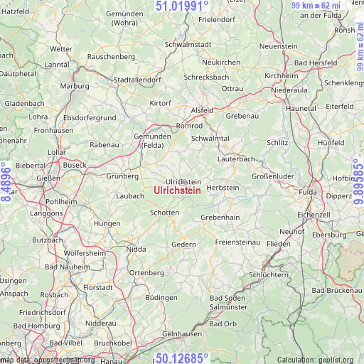
Ulrichstein GPS coordinates[2]
50° 34' 31.8" North, 9° 11' 33.792" East
| Map corner | latitude | longitude |
|---|---|---|
| Upper-left | 51.01991°, | 8.4896° |
| Center: | 50.5755°, | 9.19272° |
| Lower-right: | 50.12685°, | 9.89585° |
| Map W x H: | 99.3×99.3 km | = 61.7×61.7mi |
| max Lat: | 55.01917° ⇑51.2% North |
| Ulrichstein: | 50.5755° |
| min Lat: | ⇓48.8% South 47.40724° |
| min Long | Ulrichstein | max Long |
| 5.92978° | 9.19272° | 14.98853° |
| W 37.5%⇐ | ⇒62.5% E |
Elevation
Elevation of Ulrichstein is 578 m = 1896 ft, and this is 328.9 m = 1079 ft above average elevation for this country.
| Max E: |
1256 m = 4121 ft | 5.8% |
| Ulrichstein | 578 m 1896 ft | |
| Avg. | 249.1 m = 817 ft | |
Min E: |
-5 m = -16 ft | 94.2% |
See also: Germany elevation on elevation.city.
Geographical zone
Ulrichstein is located in North temperate zone (between Tropic of Cancer and the Arctic Circle). Distance of this North polar circle is 1777.7 km =1104.6 mi to North.| Distance of | km | miles | from Ulrichstein |
|---|---|---|---|
| North Pole | 4383.6 | 2723.8 | to North |
| Arctic Circle | 1777.7 | 1104.6 | to North |
| Tropic Cancer | 3017.5 | 1875 | to South |
| Equator | 5623.5 | 3494.3 | to South |


Nearby cities:
15 places around Ulrichstein: (largest is in red/bold)
• Alsfeld
20.4 km =12.7 mi,  15°
15°
• Gedern
16.8 km =10.4 mi,  178°
178°
• Grebenhain
14.1 km =8.8 mi,  132°
132°
• Grünberg
16.7 km =10.4 mi,  277°
277°
• Herbstein
10.9 km =6.8 mi,  98°
98°
• Hirzenhain
20 km =12.4 mi,  192°
192°
• Homberg
22.2 km =13.8 mi,  321°
321°
• Hosenfeld
21.7 km =13.5 mi,  111°
111°
• Laubach
14.8 km =9.2 mi,  255°
255°
• Lauterbach
15.9 km =9.9 mi,  65°
65°
• Lautertal
6.5 km =4 mi,  82°
82°
• Nidda
22.3 km =13.9 mi,  216°
216°
• Romrod
15.5 km =9.6 mi,  7°
7°
• Schotten
9.3 km =5.8 mi,  210°
210°
• Schwalmtal
12.1 km =7.5 mi, 8°
Sources, notices
• [Note1] Compared only with cities in Germany existing in our database
• [Src1] Map data: © OpenStreetMap contributors (CC-BY-SA)
• [Src2] Other city data from geonames.org with taken over terms of usage.
• [Src3] Geographical zone / Annual Mean Temperature by Robert A. Rohde @ Wikipedia
