Lauterbach geodata
Lauterbach (Hesse) is a seat of a third-order administrative division; located in Germany in Europe/Berlin (GMT+2) time zone. With population of 14,487 people, there are 1092 cities with bigger population in this country. Compared to other cities in Germany, 50.4% of cities are located further ↓South; 59.3% of cities are located further →East and 60.2% of cities have lower elevation than Lauterbach. Note1
Administrative division(s):
- Level 1: Hesse
- Level 2: Regierungsbezirk Gießen
- Level 3: Vogelsbergkreis
- Level 4: Lauterbach (Hessen), Kreisstadt


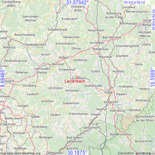
Lauterbach GPS coordinates[2]
50° 38' 8.088" North, 9° 23' 51.972" East
| Map corner | latitude | longitude |
|---|---|---|
| Upper-left | 51.07942°, | 8.69465° |
| Center: | 50.63558°, | 9.39777° |
| Lower-right: | 50.1875°, | 10.1009° |
| Map W x H: | 99.2×99.2 km | = 61.6×61.6mi |
| max Lat: | 55.01917° ⇑49.6% North |
| Lauterbach: | 50.63558° |
| min Lat: | ⇓50.4% South 47.40724° |
| min Long | Lauterbach | max Long |
| 5.92978° | 9.39777° | 14.98853° |
| W 40.7%⇐ | ⇒59.3% E |
Elevation
Elevation of Lauterbach is 291 m = 955 ft, and this is 41.9 m = 137 ft above average elevation for this country.
| Max E: |
1256 m = 4121 ft | 39.8% |
| Lauterbach | 291 m 955 ft | |
| Avg. | 249.1 m = 817 ft | |
Min E: |
-5 m = -16 ft | 60.2% |
See also: Germany elevation on elevation.city.
Geographical zone
Lauterbach is located in North temperate zone (between Tropic of Cancer and the Arctic Circle). Distance of this North polar circle is 1771 km =1100.4 mi to North.| Distance of | km | miles | from Lauterbach |
|---|---|---|---|
| North Pole | 4376.9 | 2719.7 | to North |
| Arctic Circle | 1771 | 1100.4 | to North |
| Tropic Cancer | 3024.2 | 1879.2 | to South |
| Equator | 5630.1 | 3498.4 | to South |


Nearby cities:
15 places around Lauterbach: (largest is in red/bold)
• Alsfeld
15.7 km =9.8 mi,  325°
325°
• Bad Salzschlirf
7.9 km =4.9 mi,  99°
99°
• Fulda
21.7 km =13.5 mi,  115°
115°
• Grebenau
13 km =8.1 mi,  24°
24°
• Grebenhain
16.8 km =10.4 mi,  194°
194°
• Großenlüder
11.3 km =7 mi, 115°
• Herbstein
9.1 km =5.7 mi,  203°
203°
• Hosenfeld
15.6 km =9.7 mi,  158°
158°
• Lautertal
9.9 km =6.2 mi,  234°
234°
• Niederaula
23.2 km =14.4 mi,  37°
37°
• Ottrau
19 km =11.8 mi,  357°
357°
• Romrod
15.2 km =9.4 mi,  304°
304°
• Schlitz
12.3 km =7.6 mi,  69°
69°
• Schwalmtal
13.8 km =8.6 mi,  292°
292°
• Ulrichstein
15.9 km =9.9 mi,  245°
245°
Sources, notices
• [Note1] Compared only with cities in Germany existing in our database
• [Src1] Map data: © OpenStreetMap contributors (CC-BY-SA)
• [Src2] Other city data from geonames.org with taken over terms of usage.
• [Src3] Geographical zone / Annual Mean Temperature by Robert A. Rohde @ Wikipedia
