Riedenburg geodata
Riedenburg (Bavaria) is a populated place; located in Germany in Europe/Berlin (GMT+2) time zone. With population of 5,689 people, there are 2571 cities with bigger population in this country. Compared to other cities in Germany, 83.4% of cities are located further ↑North; 77.1% of cities are located further ←West and 71.8% of cities have lower elevation than Riedenburg. Note1
Administrative division(s):
- Level 1: Bavaria
- Level 2: Lower Bavaria
- Level 3: Landkreis Kelheim
- Level 4: Riedenburg


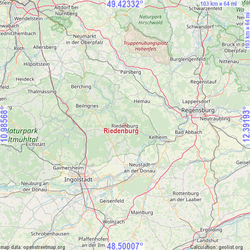
Riedenburg GPS coordinates[2]
48° 57' 49.788" North, 11° 41' 19.68" East
| Map corner | latitude | longitude |
|---|---|---|
| Upper-left | 49.42332°, | 10.98568° |
| Center: | 48.96383°, | 11.6888° |
| Lower-right: | 48.50007°, | 12.39193° |
| Map W x H: | 102.7×102.7 km | = 63.8×63.8mi |
| max Lat: | 55.01917° ⇑83.4% North |
| Riedenburg: | 48.96383° |
| min Lat: | ⇓16.6% South 47.40724° |
| min Long | Riedenburg | max Long |
| 5.92978° | 11.6888° | 14.98853° |
| W 77.1%⇐ | ⇒22.9% E |
Elevation
Elevation of Riedenburg is 373 m = 1224 ft, and this is 123.9 m = 406 ft above average elevation for this country.
| Max E: |
1256 m = 4121 ft | 28.2% |
| Riedenburg | 373 m 1224 ft | |
| Avg. | 249.1 m = 817 ft | |
Min E: |
-5 m = -16 ft | 71.8% |
See also: Germany elevation on elevation.city.
Geographical zone
Riedenburg is located in North temperate zone (between Tropic of Cancer and the Arctic Circle). Distance of this North polar circle is 1956.9 km =1216 mi to North.| Distance of | km | miles | from Riedenburg |
|---|---|---|---|
| North Pole | 4562.8 | 2835.2 | to North |
| Arctic Circle | 1956.9 | 1216 | to North |
| Tropic Cancer | 2838.3 | 1763.6 | to South |
| Equator | 5444.3 | 3382.9 | to South |


Nearby cities:
15 places around Riedenburg: (largest is in red/bold)
• Abensberg
20.1 km =12.5 mi,  144°
144°
• Beratzhausen
17.1 km =10.6 mi,  31°
31°
• Denkendorf
17.4 km =10.8 mi,  256°
256°
• Deuerling
18.1 km =11.2 mi,  63°
63°
• Dietfurt
11 km =6.8 mi,  316°
316°
• Essing
8.1 km =5 mi,  113°
113°
• Hemau
12.1 km =7.5 mi, 34°
• Ihrlerstein
13.4 km =8.3 mi,  104°
104°
• Kelheim
15.3 km =9.5 mi, 109°
• Mindelstetten
13 km =8.1 mi,  192°
192°
• Neustadt an der Donau
18.4 km =11.4 mi,  161°
161°
• Oberdolling
16.5 km =10.3 mi,  205°
205°
• Painten
10.2 km =6.3 mi,  68°
68°
• Saal
19.1 km =11.9 mi, 111°
• Stammham
20.9 km =13 mi,  234°
234°
Sources, notices
• [Note1] Compared only with cities in Germany existing in our database
• [Src1] Map data: © OpenStreetMap contributors (CC-BY-SA)
• [Src2] Other city data from geonames.org with taken over terms of usage.
• [Src3] Geographical zone / Annual Mean Temperature by Robert A. Rohde @ Wikipedia
