Denkendorf geodata
Denkendorf (Bavaria) is a seat of a fourth-order administrative division; located in Germany in Europe/Berlin (GMT+2) time zone. In our database, there are 11009 cities with bigger population. Compared to other cities in Germany, 83.8% of cities are located further ↑North; 73.6% of cities are located further ←West and 86.6% of cities have lower elevation than Denkendorf. Note1
Administrative division(s):
- Level 1: Bavaria
- Level 2: Upper Bavaria
- Level 3: Landkreis Eichstätt
- Level 4: Denkendorf


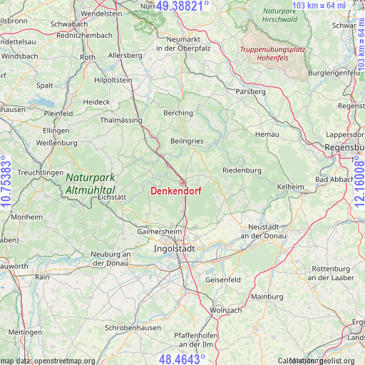
Denkendorf GPS coordinates[2]
48° 55' 42.204" North, 11° 27' 25.02" East
| Map corner | latitude | longitude |
|---|---|---|
| Upper-left | 49.38821°, | 10.75383° |
| Center: | 48.92839°, | 11.45695° |
| Lower-right: | 48.4643°, | 12.16008° |
| Map W x H: | 102.7×102.7 km | = 63.8×63.8mi |
| max Lat: | 55.01917° ⇑83.8% North |
| Denkendorf: | 48.92839° |
| min Lat: | ⇓16.2% South 47.40724° |
| min Long | Denkendorf | max Long |
| 5.92978° | 11.45695° | 14.98853° |
| W 73.6%⇐ | ⇒26.4% E |
Elevation
Elevation of Denkendorf is 482 m = 1581 ft, and this is 232.9 m = 764 ft above average elevation for this country.
| Max E: |
1256 m = 4121 ft | 13.4% |
| Denkendorf | 482 m 1581 ft | |
| Avg. | 249.1 m = 817 ft | |
Min E: |
-5 m = -16 ft | 86.6% |
See also: Germany elevation on elevation.city.
Geographical zone
Denkendorf is located in North temperate zone (between Tropic of Cancer and the Arctic Circle). Distance of this North polar circle is 1960.8 km =1218.4 mi to North.| Distance of | km | miles | from Denkendorf |
|---|---|---|---|
| North Pole | 4566.7 | 2837.6 | to North |
| Arctic Circle | 1960.8 | 1218.4 | to North |
| Tropic Cancer | 2834.4 | 1761.2 | to South |
| Equator | 5440.3 | 3380.4 | to South |


Nearby cities:
15 places around Denkendorf: (largest is in red/bold)
• Buxheim
18.1 km =11.2 mi,  221°
221°
• Böhmfeld
9.9 km =6.2 mi, 220°
• Dietfurt
15.2 km =9.4 mi,  38°
38°
• Eitensheim
16.1 km =10 mi, 219°
• Gaimersheim
15 km =9.3 mi,  205°
205°
• Greding
15.1 km =9.4 mi,  331°
331°
• Hepberg
11.8 km =7.3 mi,  178°
178°
• Hitzhofen
13.5 km =8.4 mi,  229°
229°
• Lenting
13.1 km =8.1 mi, 179°
• Mindelstetten
16.6 km =10.3 mi,  121°
121°
• Oberdolling
14.8 km =9.2 mi,  137°
137°
• Riedenburg
17.4 km =10.8 mi,  76°
76°
• Stammham
8.1 km =5 mi, 180°
• Walting
11.5 km =7.1 mi,  263°
263°
• Wettstetten
12.2 km =7.6 mi,  194°
194°
Sources, notices
• [Note1] Compared only with cities in Germany existing in our database
• [Src1] Map data: © OpenStreetMap contributors (CC-BY-SA)
• [Src2] Other city data from geonames.org with taken over terms of usage.
• [Src3] Geographical zone / Annual Mean Temperature by Robert A. Rohde @ Wikipedia
