Meckenheim geodata
Meckenheim (North Rhine-Westphalia) is a populated place; located in Germany in Europe/Berlin (GMT+2) time zone. With population of 25,515 people, there are 570 cities with bigger population in this country. Compared to other cities in Germany, 50.1% of cities are located further ↓South; 93% of cities are located further →East and 55.5% of cities have higher elevation than Meckenheim. Note1
Administrative division(s):
- Level 1: North Rhine-Westphalia
- Level 2: Regierungsbezirk Köln
- Level 3: Rhein-Sieg-Kreis
- Level 4: Meckenheim


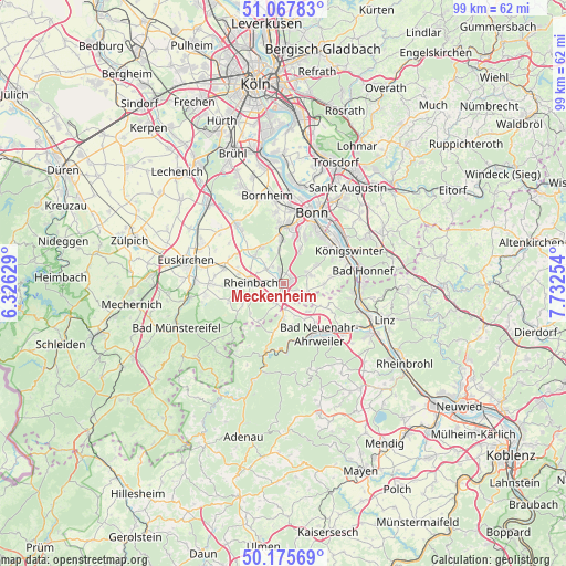
Meckenheim GPS coordinates[2]
50° 37' 25.968" North, 7° 1' 45.912" East
| Map corner | latitude | longitude |
|---|---|---|
| Upper-left | 51.06783°, | 6.32629° |
| Center: | 50.62388°, | 7.02942° |
| Lower-right: | 50.17569°, | 7.73254° |
| Map W x H: | 99.2×99.2 km | = 61.6×61.6mi |
| max Lat: | 55.01917° ⇑49.9% North |
| Meckenheim: | 50.62388° |
| min Lat: | ⇓50.1% South 47.40724° |
| min Long | Meckenheim | max Long |
| 5.92978° | 7.02942° | 14.98853° |
| W 7%⇐ | ⇒93% E |
Elevation
Elevation of Meckenheim is 185 m = 607 ft, and this is 64.1 m = 210 ft below average elevation for this country.
| Max E: |
1256 m = 4121 ft | 55.5% |
| Avg. | 249.1 m = 817 ft | |
| Meckenheim | 185 m = 607 ft | |
Min E: |
-5 m = -16 ft | 44.5% |
See also: Germany elevation on elevation.city.
Geographical zone
Meckenheim is located in North temperate zone (between Tropic of Cancer and the Arctic Circle). Distance of this North polar circle is 1772.3 km =1101.3 mi to North.| Distance of | km | miles | from Meckenheim |
|---|---|---|---|
| North Pole | 4378.2 | 2720.5 | to North |
| Arctic Circle | 1772.3 | 1101.3 | to North |
| Tropic Cancer | 3022.9 | 1878.3 | to South |
| Equator | 5628.8 | 3497.6 | to South |


Nearby cities:
15 places around Meckenheim: (largest is in red/bold)
• Alfter
12.2 km =7.6 mi,  355°
355°
• Altenahr
12.2 km =7.6 mi,  192°
192°
• Bad Honnef
14.2 km =8.8 mi,  81°
81°
• Bad Neuenahr-Ahrweiler
10.7 km =6.6 mi,  147°
147°
• Berg
9.5 km =5.9 mi,  216°
216°
• Bonn
13.1 km =8.1 mi,  20°
20°
• Dernau
10.2 km =6.3 mi,  171°
171°
• Kalenborn
8.5 km =5.3 mi, 194°
• Königswinter
12.9 km =8 mi,  59°
59°
• Mayschoß
11.5 km =7.1 mi,  184°
184°
• Rech
11.9 km =7.4 mi, 178°
• Rheinbach
5.7 km =3.5 mi,  271°
271°
• Rheinbreitbach
14.4 km =8.9 mi,  93°
93°
• Unkel
13.7 km =8.5 mi,  102°
102°
• Wachtberg
5.1 km =3.2 mi, 78°
Sources, notices
• [Note1] Compared only with cities in Germany existing in our database
• [Src1] Map data: © OpenStreetMap contributors (CC-BY-SA)
• [Src2] Other city data from geonames.org with taken over terms of usage.
• [Src3] Geographical zone / Annual Mean Temperature by Robert A. Rohde @ Wikipedia
