Wachtberg geodata
Wachtberg (North Rhine-Westphalia) is a seat of a fourth-order administrative division; located in Germany in Europe/Berlin (GMT+2) time zone. With population of 20,032 people, there are 776 cities with bigger population in this country. Compared to other cities in Germany, 50.3% of cities are located further ↓South; 92.4% of cities are located further →East and 54.4% of cities have higher elevation than Wachtberg. Note1
Administrative division(s):
- Level 1: North Rhine-Westphalia
- Level 2: Regierungsbezirk Köln
- Level 3: Rhein-Sieg-Kreis
- Level 4: Wachtberg


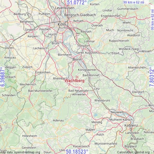
Wachtberg GPS coordinates[2]
50° 37' 59.988" North, 7° 6' 0" East
| Map corner | latitude | longitude |
|---|---|---|
| Upper-left | 51.0772°, | 6.39687° |
| Center: | 50.63333°, | 7.1° |
| Lower-right: | 50.18523°, | 7.80312° |
| Map W x H: | 99.2×99.2 km | = 61.6×61.6mi |
| max Lat: | 55.01917° ⇑49.7% North |
| Wachtberg: | 50.63333° |
| min Lat: | ⇓50.3% South 47.40724° |
| min Long | Wachtberg | max Long |
| 5.92978° | 7.1° | 14.98853° |
| W 7.6%⇐ | ⇒92.4% E |
Elevation
Elevation of Wachtberg is 194 m = 636 ft, and this is 55.1 m = 181 ft below average elevation for this country.
| Max E: |
1256 m = 4121 ft | 54.4% |
| Avg. | 249.1 m = 817 ft | |
| Wachtberg | 194 m = 636 ft | |
Min E: |
-5 m = -16 ft | 45.6% |
See also: Germany elevation on elevation.city.
Geographical zone
Wachtberg is located in North temperate zone (between Tropic of Cancer and the Arctic Circle). Distance of this North polar circle is 1771.3 km =1100.6 mi to North.| Distance of | km | miles | from Wachtberg |
|---|---|---|---|
| North Pole | 4377.2 | 2719.9 | to North |
| Arctic Circle | 1771.3 | 1100.6 | to North |
| Tropic Cancer | 3024 | 1879 | to South |
| Equator | 5629.9 | 3498.3 | to South |


Nearby cities:
15 places around Wachtberg: (largest is in red/bold)
• Alfter
12.6 km =7.8 mi,  332°
332°
• Bad Honnef
9.1 km =5.7 mi,  82°
82°
• Bad Neuenahr-Ahrweiler
10.1 km =6.3 mi,  175°
175°
• Bonn
11.2 km =7 mi,  358°
358°
• Bruchhausen
11.2 km =7 mi,  109°
109°
• Dernau
11.7 km =7.3 mi,  197°
197°
• Erpel
10.9 km =6.8 mi,  120°
120°
• Kalenborn
11.6 km =7.2 mi,  217°
217°
• Kasbach-Ohlenberg
13 km =8.1 mi, 115°
• Königswinter
8.3 km =5.2 mi,  47°
47°
• Meckenheim
5.1 km =3.2 mi,  258°
258°
• Remagen
10.8 km =6.7 mi, 124°
• Rheinbach
10.7 km =6.6 mi,  265°
265°
• Rheinbreitbach
9.6 km =6 mi,  101°
101°
• Unkel
9.3 km =5.8 mi, 116°
Sources, notices
• [Note1] Compared only with cities in Germany existing in our database
• [Src1] Map data: © OpenStreetMap contributors (CC-BY-SA)
• [Src2] Other city data from geonames.org with taken over terms of usage.
• [Src3] Geographical zone / Annual Mean Temperature by Robert A. Rohde @ Wikipedia
