Syrau geodata
Syrau (Saxony) is a populated place; located in Germany in Europe/Berlin (GMT+2) time zone. With population of 1,754 people, there are 5419 cities with bigger population in this country. Compared to other cities in Germany, 51.9% of cities are located further ↑North; 82.9% of cities are located further ←West and 84.3% of cities have lower elevation than Syrau. Note1


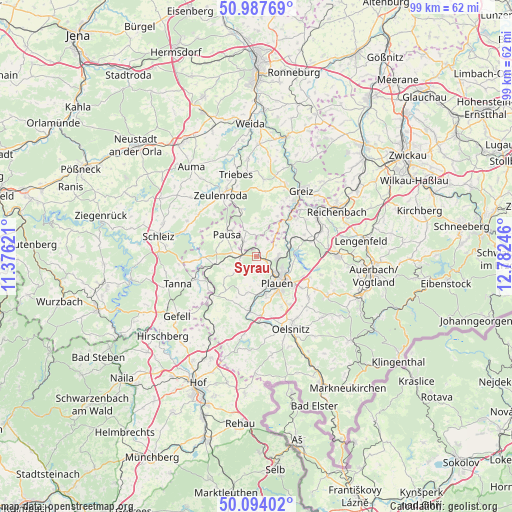
Syrau GPS coordinates[2]
50° 32' 34.692" North, 12° 4' 45.588" East
| Map corner | latitude | longitude |
|---|---|---|
| Upper-left | 50.98769°, | 11.37621° |
| Center: | 50.54297°, | 12.07933° |
| Lower-right: | 50.09402°, | 12.78246° |
| Map W x H: | 99.4×99.4 km | = 61.8×61.8mi |
| max Lat: | 55.01917° ⇑51.9% North |
| Syrau: | 50.54297° |
| min Lat: | ⇓48.1% South 47.40724° |
| min Long | Syrau | max Long |
| 5.92978° | 12.07933° | 14.98853° |
| W 82.9%⇐ | ⇒17.1% E |
Elevation
Elevation of Syrau is 463 m = 1519 ft, and this is 213.9 m = 702 ft above average elevation for this country.
| Max E: |
1256 m = 4121 ft | 15.7% |
| Syrau | 463 m 1519 ft | |
| Avg. | 249.1 m = 817 ft | |
Min E: |
-5 m = -16 ft | 84.3% |
See also: Germany elevation on elevation.city.
Geographical zone
Syrau is located in North temperate zone (between Tropic of Cancer and the Arctic Circle). Distance of this North polar circle is 1781.3 km =1106.8 mi to North.| Distance of | km | miles | from Syrau |
|---|---|---|---|
| North Pole | 4387.2 | 2726.1 | to North |
| Arctic Circle | 1781.3 | 1106.8 | to North |
| Tropic Cancer | 3013.9 | 1872.8 | to South |
| Equator | 5619.9 | 3492 | to South |


Nearby cities:
15 places around Syrau: (largest is in red/bold)
• Elsterberg
9.6 km =6 mi,  40°
40°
• Langenwolschendorf
13.6 km =8.5 mi,  319°
319°
• Limbach
12.9 km =8 mi,  69°
69°
• Mehltheuer
3 km =1.9 mi,  274°
274°
• Mühltroff
10.7 km =6.6 mi, 267°
• Netzschkau
14.1 km =8.8 mi,  55°
55°
• Neuensalz
10.8 km =6.7 mi,  116°
116°
• Pausa
7.2 km =4.5 mi,  306°
306°
• Plauen
6.5 km =4 mi,  140°
140°
• Pöhl
7.4 km =4.6 mi,  83°
83°
• Reuth
11.8 km =7.3 mi,  226°
226°
• Reuth
12.7 km =7.9 mi,  49°
49°
• Theuma
12.9 km =8 mi,  128°
128°
• Weischlitz
10.4 km =6.5 mi,  184°
184°
• Zeulenroda
13.9 km =8.6 mi,  331°
331°
Sources, notices
• [Note1] Compared only with cities in Germany existing in our database
• [Src1] Map data: © OpenStreetMap contributors (CC-BY-SA)
• [Src2] Other city data from geonames.org with taken over terms of usage.
• [Src3] Geographical zone / Annual Mean Temperature by Robert A. Rohde @ Wikipedia
