Oberhausen geodata
Oberhausen (Bavaria) is a seat of a fourth-order administrative division; located in Germany in Europe/Berlin (GMT+2) time zone. With population of 2,558 people, there are 4372 cities with bigger population in this country. Compared to other cities in Germany, 86.2% of cities are located further ↑North; 68.5% of cities are located further ←West and 78.2% of cities have lower elevation than Oberhausen. Note1
Administrative division(s):
- Level 1: Bavaria
- Level 2: Upper Bavaria
- Level 3: Landkreis Neuburg-Schrobenhausen
- Level 4: Oberhausen


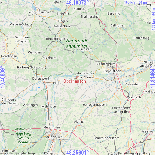
Oberhausen GPS coordinates[2]
48° 43' 19.236" North, 11° 6' 41.436" East
| Map corner | latitude | longitude |
|---|---|---|
| Upper-left | 49.18373°, | 10.40839° |
| Center: | 48.72201°, | 11.11151° |
| Lower-right: | 48.25601°, | 11.81464° |
| Map W x H: | 103.2×103.2 km | = 64.1×64.1mi |
| max Lat: | 55.01917° ⇑86.2% North |
| Oberhausen: | 48.72201° |
| min Lat: | ⇓13.8% South 47.40724° |
| min Long | Oberhausen | max Long |
| 5.92978° | 11.11151° | 14.98853° |
| W 68.5%⇐ | ⇒31.5% E |
Elevation
Elevation of Oberhausen is 421 m = 1381 ft, and this is 171.9 m = 564 ft above average elevation for this country.
| Max E: |
1256 m = 4121 ft | 21.8% |
| Oberhausen | 421 m 1381 ft | |
| Avg. | 249.1 m = 817 ft | |
Min E: |
-5 m = -16 ft | 78.2% |
See also: Germany elevation on elevation.city.
Geographical zone
Oberhausen is located in North temperate zone (between Tropic of Cancer and the Arctic Circle). Distance of this North polar circle is 1983.8 km =1232.7 mi to North.| Distance of | km | miles | from Oberhausen |
|---|---|---|---|
| North Pole | 4589.7 | 2851.9 | to North |
| Arctic Circle | 1983.8 | 1232.7 | to North |
| Tropic Cancer | 2811.5 | 1747 | to South |
| Equator | 5417.4 | 3366.2 | to South |


Nearby cities:
15 places around Oberhausen: (largest is in red/bold)
• Adelschlag
15.3 km =9.5 mi,  30°
30°
• Berg im Gau
14.2 km =8.8 mi,  134°
134°
• Bergheim
11.5 km =7.1 mi,  68°
68°
• Burgheim
7.4 km =4.6 mi,  251°
251°
• Egweil
11.2 km =7 mi,  52°
52°
• Ehekirchen
9.9 km =6.2 mi,  184°
184°
• Karlshuld
13.5 km =8.4 mi,  109°
109°
• Langenmosen
14.9 km =9.3 mi,  149°
149°
• Marxheim
12.4 km =7.7 mi,  280°
280°
• Neuburg an der Donau
5.7 km =3.5 mi,  78°
78°
• Niederschönenfeld
13.1 km =8.1 mi,  267°
267°
• Rain
14.8 km =9.2 mi,  256°
256°
• Rennertshofen
6.4 km =4 mi,  310°
310°
• Rohrenfels
5.1 km =3.2 mi,  140°
140°
• Tagmersheim
14.9 km =9.3 mi, 314°
Sources, notices
• [Note1] Compared only with cities in Germany existing in our database
• [Src1] Map data: © OpenStreetMap contributors (CC-BY-SA)
• [Src2] Other city data from geonames.org with taken over terms of usage.
• [Src3] Geographical zone / Annual Mean Temperature by Robert A. Rohde @ Wikipedia
