Gerolsbach geodata
Gerolsbach (Bavaria) is a seat of a fourth-order administrative division; located in Germany in Europe/Berlin (GMT+2) time zone. With population of 3,244 people, there are 3792 cities with bigger population in this country. Compared to other cities in Germany, 89.2% of cities are located further ↑North; 72.1% of cities are located further ←West and 84.1% of cities have lower elevation than Gerolsbach. Note1
Administrative division(s):
- Level 1: Bavaria
- Level 2: Upper Bavaria
- Level 3: Landkreis Pfaffenhofen an der Ilm
- Level 4: Gerolsbach


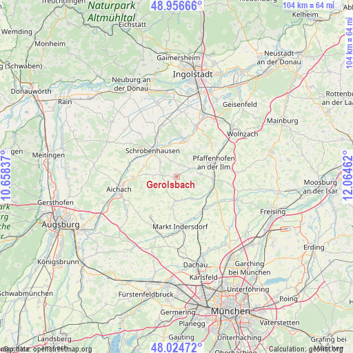
Gerolsbach GPS coordinates[2]
48° 29' 34.188" North, 11° 21' 41.364" East
| Map corner | latitude | longitude |
|---|---|---|
| Upper-left | 48.95666°, | 10.65837° |
| Center: | 48.49283°, | 11.36149° |
| Lower-right: | 48.02472°, | 12.06462° |
| Map W x H: | 103.6×103.6 km | = 64.4×64.4mi |
| max Lat: | 55.01917° ⇑89.2% North |
| Gerolsbach: | 48.49283° |
| min Lat: | ⇓10.8% South 47.40724° |
| min Long | Gerolsbach | max Long |
| 5.92978° | 11.36149° | 14.98853° |
| W 72.1%⇐ | ⇒27.9% E |
Elevation
Elevation of Gerolsbach is 462 m = 1516 ft, and this is 212.9 m = 698 ft above average elevation for this country.
| Max E: |
1256 m = 4121 ft | 15.9% |
| Gerolsbach | 462 m 1516 ft | |
| Avg. | 249.1 m = 817 ft | |
Min E: |
-5 m = -16 ft | 84.1% |
See also: Germany elevation on elevation.city.
Geographical zone
Gerolsbach is located in North temperate zone (between Tropic of Cancer and the Arctic Circle). Distance of this North polar circle is 2009.3 km =1248.5 mi to North.| Distance of | km | miles | from Gerolsbach |
|---|---|---|---|
| North Pole | 4615.2 | 2867.8 | to North |
| Arctic Circle | 2009.3 | 1248.5 | to North |
| Tropic Cancer | 2786 | 1731.1 | to South |
| Equator | 5391.9 | 3350.4 | to South |


Nearby cities:
15 places around Gerolsbach: (largest is in red/bold)
• Aresing
6.4 km =4 mi,  314°
314°
• Gachenbach
9.5 km =5.9 mi,  274°
274°
• Hettenshausen
10.2 km =6.3 mi,  85°
85°
• Hilgertshausen-Tandern
7.1 km =4.4 mi,  184°
184°
• Ilmmünster
10.3 km =6.4 mi,  95°
95°
• Jetzendorf
7.8 km =4.8 mi,  148°
148°
• Petershausen
12.3 km =7.6 mi,  138°
138°
• Pfaffenhofen an der Ilm
11.4 km =7.1 mi,  68°
68°
• Reichertshausen
11.8 km =7.3 mi, 104°
• Ried
7.6 km =4.7 mi,  256°
256°
• Scheyern
7.8 km =4.8 mi,  84°
84°
• Schiltberg
8.9 km =5.5 mi,  248°
248°
• Schrobenhausen
10.6 km =6.6 mi,  315°
315°
• Schwabhausen
10.2 km =6.3 mi, 181°
• Waidhofen
9.5 km =5.9 mi,  348°
348°
Sources, notices
• [Note1] Compared only with cities in Germany existing in our database
• [Src1] Map data: © OpenStreetMap contributors (CC-BY-SA)
• [Src2] Other city data from geonames.org with taken over terms of usage.
• [Src3] Geographical zone / Annual Mean Temperature by Robert A. Rohde @ Wikipedia
