Esperstedt geodata
Esperstedt (Saxony-Anhalt) is a populated place; located in Germany in Europe/Berlin (GMT+2) time zone. With population of 748 people, there are 8109 cities with bigger population in this country. Compared to other cities in Germany, 65.2% of cities are located further ↓South; 76.9% of cities are located further ←West and 62.7% of cities have higher elevation than Esperstedt. Note1


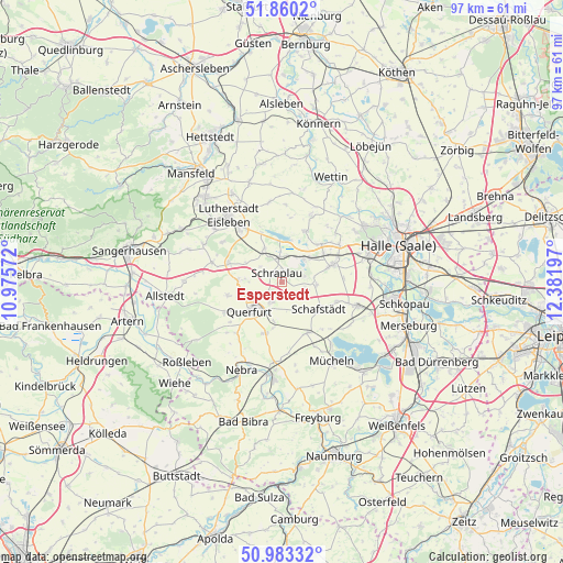
Esperstedt GPS coordinates[2]
51° 25' 25.896" North, 11° 40' 43.824" East
| Map corner | latitude | longitude |
|---|---|---|
| Upper-left | 51.8602°, | 10.97572° |
| Center: | 51.42386°, | 11.67884° |
| Lower-right: | 50.98332°, | 12.38197° |
| Map W x H: | 97.5×97.5 km | = 60.6×60.6mi |
| max Lat: | 55.01917° ⇑34.8% North |
| Esperstedt: | 51.42386° |
| min Lat: | ⇓65.2% South 47.40724° |
| min Long | Esperstedt | max Long |
| 5.92978° | 11.67884° | 14.98853° |
| W 76.9%⇐ | ⇒23.1% E |
Elevation
Elevation of Esperstedt is 134 m = 440 ft, and this is 115.1 m = 378 ft below average elevation for this country.
| Max E: |
1256 m = 4121 ft | 62.7% |
| Avg. | 249.1 m = 817 ft | |
| Esperstedt | 134 m = 440 ft | |
Min E: |
-5 m = -16 ft | 37.3% |
See also: Germany elevation on elevation.city.
Geographical zone
Esperstedt is located in North temperate zone (between Tropic of Cancer and the Arctic Circle). Distance of this North polar circle is 1683.4 km =1046 mi to North.| Distance of | km | miles | from Esperstedt |
|---|---|---|---|
| North Pole | 4289.3 | 2665.2 | to North |
| Arctic Circle | 1683.4 | 1046 | to North |
| Tropic Cancer | 3111.9 | 1933.6 | to South |
| Equator | 5717.8 | 3552.9 | to South |


Nearby cities:
15 places around Esperstedt: (largest is in red/bold)
• Alberstedt
4.6 km =2.9 mi,  305°
305°
• Amsdorf
5.6 km =3.5 mi,  36°
36°
• Dornstedt
4.9 km =3 mi,  107°
107°
• Erdeborn
6.5 km =4 mi,  332°
332°
• Farnstädt
7.8 km =4.8 mi,  277°
277°
• Nemsdorf-Göhrendorf
8.5 km =5.3 mi,  193°
193°
• Obhausen
4 km =2.5 mi,  206°
206°
• Querfurt
7.2 km =4.5 mi,  228°
228°
• Röblingen am See
4 km =2.5 mi,  3°
3°
• Schafstädt
8.1 km =5 mi,  125°
125°
• Schraplau
1.7 km =1.1 mi, 334°
• Seeburg
7.6 km =4.7 mi,  12°
12°
• Stedten
2.3 km =1.4 mi,  24°
24°
• Steuden
6.1 km =3.8 mi,  95°
95°
• Wansleben
6.5 km =4 mi,  51°
51°
Sources, notices
• [Note1] Compared only with cities in Germany existing in our database
• [Src1] Map data: © OpenStreetMap contributors (CC-BY-SA)
• [Src2] Other city data from geonames.org with taken over terms of usage.
• [Src3] Geographical zone / Annual Mean Temperature by Robert A. Rohde @ Wikipedia
