Alberstedt geodata
Alberstedt (Saxony-Anhalt) is a populated place; located in Germany in Europe/Berlin (GMT+2) time zone. With population of 518 people, there are 9265 cities with bigger population in this country. Compared to other cities in Germany, 65.5% of cities are located further ↓South; 76.1% of cities are located further ←West and 58% of cities have higher elevation than Alberstedt. Note1


Alberstedt GPS coordinates[2]
51° 26' 51.288" North, 11° 37' 30.396" East
| Map corner | latitude | longitude |
|---|---|---|
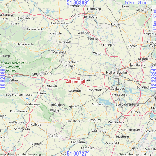
| Upper-left | 51.88369°, | 10.92199° |
| Center: | 51.44758°, | 11.62511° |
| Lower-right: | 51.00727°, | 12.32824° |
| Map W x H: | 97.4×97.4 km | = 60.5×60.5mi |
| max Lat: | 55.01917° ⇑34.5% North |
| Alberstedt: | 51.44758° |
| min Lat: | ⇓65.5% South 47.40724° |
| min Long | Alberstedt | max Long |
| 5.92978° | 11.62511° | 14.98853° |
| W 76.1%⇐ | ⇒23.9% E |
Elevation
Elevation of Alberstedt is 168 m = 551 ft, and this is 81.1 m = 266 ft below average elevation for this country.
| Max E: |
1256 m = 4121 ft | 58% |
| Avg. | 249.1 m = 817 ft | |
| Alberstedt | 168 m = 551 ft | |
Min E: |
-5 m = -16 ft | 42% |
See also: Germany elevation on elevation.city.
Geographical zone
Alberstedt is located in North temperate zone (between Tropic of Cancer and the Arctic Circle). Distance of this North polar circle is 1680.7 km =1044.3 mi to North.| Distance of | km | miles | from Alberstedt |
|---|---|---|---|
| North Pole | 4286.6 | 2663.6 | to North |
| Arctic Circle | 1680.7 | 1044.3 | to North |
| Tropic Cancer | 3114.5 | 1935.3 | to South |
| Equator | 5720.4 | 3554.5 | to South |


Nearby cities:
15 places around Alberstedt: (largest is in red/bold)
• Amsdorf
7.3 km =4.5 mi,  75°
75°
• Bischofrode
7.8 km =4.8 mi,  303°
303°
• Erdeborn
3.2 km =2 mi,  12°
12°
• Esperstedt
4.6 km =2.9 mi,  125°
125°
• Farnstädt
4.3 km =2.7 mi,  248°
248°
• Lüttchendorf
6 km =3.7 mi,  1°
1°
• Obhausen
6.5 km =4 mi,  162°
162°
• Osterhausen
8.4 km =5.2 mi,  275°
275°
• Querfurt
7.6 km =4.7 mi,  193°
193°
• Rothenschirmbach
5.5 km =3.4 mi, 279°
• Röblingen am See
4.2 km =2.6 mi,  71°
71°
• Schraplau
3.2 km =2 mi,  110°
110°
• Seeburg
7.2 km =4.5 mi,  48°
48°
• Stedten
4.7 km =2.9 mi,  96°
96°
• Wansleben
8.9 km =5.5 mi, 80°
Sources, notices
• [Note1] Compared only with cities in Germany existing in our database
• [Src1] Map data: © OpenStreetMap contributors (CC-BY-SA)
• [Src2] Other city data from geonames.org with taken over terms of usage.
• [Src3] Geographical zone / Annual Mean Temperature by Robert A. Rohde @ Wikipedia
