Poing geodata
Poing (Bavaria) is a seat of a fourth-order administrative division; located in Germany in Europe/Berlin (GMT+2) time zone. With population of 11,592 people, there are 1418 cities with bigger population in this country. Compared to other cities in Germany, 93.1% of cities are located further ↑North; 79.1% of cities are located further ←West and 90.4% of cities have lower elevation than Poing. Note1
Administrative division(s):
- Level 1: Bavaria
- Level 2: Upper Bavaria
- Level 3: Landkreis Ebersberg
- Level 4: Poing


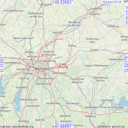
Poing GPS coordinates[2]
48° 10' 12.144" North, 11° 49' 7.068" East
| Map corner | latitude | longitude |
|---|---|---|
| Upper-left | 48.63683°, | 11.11551° |
| Center: | 48.17004°, | 11.81863° |
| Lower-right: | 47.69897°, | 12.52176° |
| Map W x H: | 104.3×104.3 km | = 64.8×64.8mi |
| max Lat: | 55.01917° ⇑93.1% North |
| Poing: | 48.17004° |
| min Lat: | ⇓6.9% South 47.40724° |
| min Long | Poing | max Long |
| 5.92978° | 11.81863° | 14.98853° |
| W 79.1%⇐ | ⇒20.9% E |
Elevation
Elevation of Poing is 519 m = 1703 ft, and this is 269.9 m = 885 ft above average elevation for this country.
| Max E: |
1256 m = 4121 ft | 9.6% |
| Poing | 519 m 1703 ft | |
| Avg. | 249.1 m = 817 ft | |
Min E: |
-5 m = -16 ft | 90.4% |
See also: Germany elevation on elevation.city.
Geographical zone
Poing is located in North temperate zone (between Tropic of Cancer and the Arctic Circle). Distance of this North polar circle is 2045.2 km =1270.8 mi to North.| Distance of | km | miles | from Poing |
|---|---|---|---|
| North Pole | 4651.1 | 2890.1 | to North |
| Arctic Circle | 2045.2 | 1270.8 | to North |
| Tropic Cancer | 2750.1 | 1708.8 | to South |
| Equator | 5356 | 3328.1 | to South |


Nearby cities:
15 places around Poing: (largest is in red/bold)
• Anzing
3.3 km =2.1 mi,  128°
128°
• Aschheim
7.6 km =4.7 mi,  270°
270°
• Feldkirchen
6.9 km =4.3 mi,  249°
249°
• Finsing
5.1 km =3.2 mi,  4°
4°
• Forstinning
7 km =4.3 mi,  91°
91°
• Grasbrunn
11.5 km =7.1 mi,  208°
208°
• Haar
9.6 km =6 mi,  225°
225°
• Kirchheim bei München
4.7 km =2.9 mi,  278°
278°
• Markt Schwaben
4.3 km =2.7 mi,  59°
59°
• Ottenhofen
7.1 km =4.4 mi,  42°
42°
• Pastetten
9.8 km =6.1 mi,  70°
70°
• Pliening
3.1 km =1.9 mi,  334°
334°
• Vaterstetten
8.1 km =5 mi, 207°
• Wörth
10.4 km =6.5 mi, 36°
• Zorneding
9.5 km =5.9 mi,  177°
177°
Sources, notices
• [Note1] Compared only with cities in Germany existing in our database
• [Src1] Map data: © OpenStreetMap contributors (CC-BY-SA)
• [Src2] Other city data from geonames.org with taken over terms of usage.
• [Src3] Geographical zone / Annual Mean Temperature by Robert A. Rohde @ Wikipedia
