Aschheim geodata
Aschheim (Bavaria) is a seat of a fourth-order administrative division; located in Germany in Europe/Berlin (GMT+2) time zone. With population of 6,531 people, there are 2302 cities with bigger population in this country. Compared to other cities in Germany, 93.1% of cities are located further ↑North; 77.5% of cities are located further ←West and 90.1% of cities have lower elevation than Aschheim. Note1
Administrative division(s):
- Level 1: Bavaria
- Level 2: Upper Bavaria
- Level 3: Landkreis München
- Level 4: Aschheim


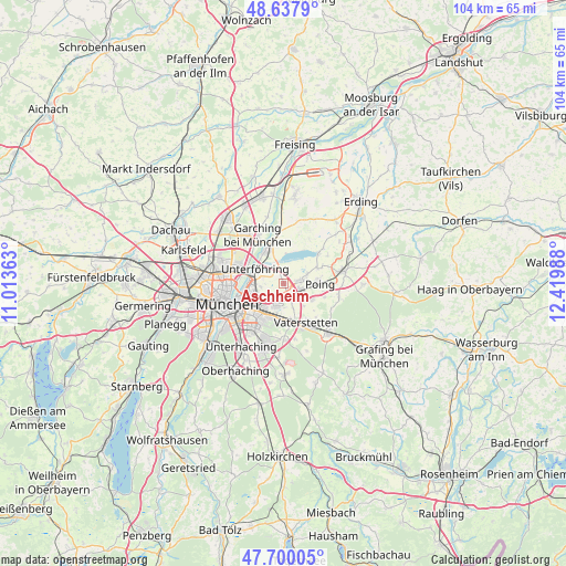
Aschheim GPS coordinates[2]
48° 10' 16.032" North, 11° 43' 0.3" East
| Map corner | latitude | longitude |
|---|---|---|
| Upper-left | 48.6379°, | 11.01363° |
| Center: | 48.17112°, | 11.71675° |
| Lower-right: | 47.70005°, | 12.41988° |
| Map W x H: | 104.3×104.3 km | = 64.8×64.8mi |
| max Lat: | 55.01917° ⇑93.1% North |
| Aschheim: | 48.17112° |
| min Lat: | ⇓6.9% South 47.40724° |
| min Long | Aschheim | max Long |
| 5.92978° | 11.71675° | 14.98853° |
| W 77.5%⇐ | ⇒22.5% E |
Elevation
Elevation of Aschheim is 515 m = 1690 ft, and this is 265.9 m = 872 ft above average elevation for this country.
| Max E: |
1256 m = 4121 ft | 9.9% |
| Aschheim | 515 m 1690 ft | |
| Avg. | 249.1 m = 817 ft | |
Min E: |
-5 m = -16 ft | 90.1% |
See also: Germany elevation on elevation.city.
Geographical zone
Aschheim is located in North temperate zone (between Tropic of Cancer and the Arctic Circle). Distance of this North polar circle is 2045 km =1270.7 mi to North.| Distance of | km | miles | from Aschheim |
|---|---|---|---|
| North Pole | 4650.9 | 2889.9 | to North |
| Arctic Circle | 2045 | 1270.7 | to North |
| Tropic Cancer | 2750.2 | 1708.9 | to South |
| Equator | 5356.1 | 3328.1 | to South |


Nearby cities:
15 places around Aschheim: (largest is in red/bold)
• Anzing
10.4 km =6.5 mi,  102°
102°
• Bogenhausen
7.8 km =4.8 mi,  254°
254°
• Feldkirchen
2.8 km =1.7 mi,  157°
157°
• Finsing
9.4 km =5.8 mi,  57°
57°
• Garching bei München
9.9 km =6.2 mi,  330°
330°
• Grasbrunn
10.4 km =6.5 mi,  168°
168°
• Haar
7 km =4.3 mi, 174°
• Ismaning
7.3 km =4.5 mi,  340°
340°
• Kirchheim bei München
2.9 km =1.8 mi,  78°
78°
• Munich
11.1 km =6.9 mi, 250°
• Pliening
6.8 km =4.2 mi,  66°
66°
• Poing
7.6 km =4.7 mi,  90°
90°
• Putzbrunn
10.6 km =6.6 mi,  180°
180°
• Unterföhring
6 km =3.7 mi,  293°
293°
• Vaterstetten
8.2 km =5.1 mi,  152°
152°
Sources, notices
• [Note1] Compared only with cities in Germany existing in our database
• [Src1] Map data: © OpenStreetMap contributors (CC-BY-SA)
• [Src2] Other city data from geonames.org with taken over terms of usage.
• [Src3] Geographical zone / Annual Mean Temperature by Robert A. Rohde @ Wikipedia
