Pastetten geodata
Pastetten (Bavaria) is a seat of a fourth-order administrative division; located in Germany in Europe/Berlin (GMT+2) time zone. With population of 2,281 people, there are 4701 cities with bigger population in this country. Compared to other cities in Germany, 92.7% of cities are located further ↑North; 81% of cities are located further ←West and 89.2% of cities have lower elevation than Pastetten. Note1
Administrative division(s):
- Level 1: Bavaria
- Level 2: Upper Bavaria
- Level 3: Landkreis Erding
- Level 4: Pastetten


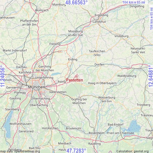
Pastetten GPS coordinates[2]
48° 11' 56.796" North, 11° 56' 37.248" East
| Map corner | latitude | longitude |
|---|---|---|
| Upper-left | 48.66563°, | 11.24056° |
| Center: | 48.19911°, | 11.94368° |
| Lower-right: | 47.7283°, | 12.64681° |
| Map W x H: | 104.2×104.2 km | = 64.7×64.7mi |
| max Lat: | 55.01917° ⇑92.7% North |
| Pastetten: | 48.19911° |
| min Lat: | ⇓7.3% South 47.40724° |
| min Long | Pastetten | max Long |
| 5.92978° | 11.94368° | 14.98853° |
| W 81%⇐ | ⇒19% E |
Elevation
Elevation of Pastetten is 505 m = 1657 ft, and this is 255.9 m = 840 ft above average elevation for this country.
| Max E: |
1256 m = 4121 ft | 10.8% |
| Pastetten | 505 m 1657 ft | |
| Avg. | 249.1 m = 817 ft | |
Min E: |
-5 m = -16 ft | 89.2% |
See also: Germany elevation on elevation.city.
Geographical zone
Pastetten is located in North temperate zone (between Tropic of Cancer and the Arctic Circle). Distance of this North polar circle is 2041.9 km =1268.8 mi to North.| Distance of | km | miles | from Pastetten |
|---|---|---|---|
| North Pole | 4647.8 | 2888 | to North |
| Arctic Circle | 2041.9 | 1268.8 | to North |
| Tropic Cancer | 2753.3 | 1710.8 | to South |
| Equator | 5359.2 | 3330.1 | to South |


Nearby cities:
15 places around Pastetten: (largest is in red/bold)
• Anzing
8.5 km =5.3 mi,  231°
231°
• Buch am Buchrain
4.2 km =2.6 mi,  64°
64°
• Finsing
9.1 km =5.7 mi,  282°
282°
• Forstern
3 km =1.9 mi,  125°
125°
• Forstinning
4.1 km =2.5 mi,  214°
214°
• Hohenlinden
6.1 km =3.8 mi,  141°
141°
• Isen
8.5 km =5.3 mi,  80°
80°
• Lengdorf
10.2 km =6.3 mi,  50°
50°
• Markt Schwaben
5.6 km =3.5 mi,  259°
259°
• Moosinning
11.4 km =7.1 mi,  319°
319°
• Ottenhofen
4.9 km =3 mi,  293°
293°
• Pliening
10.6 km =6.6 mi,  267°
267°
• Poing
9.8 km =6.1 mi,  250°
250°
• Walpertskirchen
7 km =4.3 mi,  19°
19°
• Wörth
6 km =3.7 mi,  329°
329°
Sources, notices
• [Note1] Compared only with cities in Germany existing in our database
• [Src1] Map data: © OpenStreetMap contributors (CC-BY-SA)
• [Src2] Other city data from geonames.org with taken over terms of usage.
• [Src3] Geographical zone / Annual Mean Temperature by Robert A. Rohde @ Wikipedia
