Forstinning geodata
Forstinning (Bavaria) is a seat of a fourth-order administrative division; located in Germany in Europe/Berlin (GMT+2) time zone. With population of 3,473 people, there are 3636 cities with bigger population in this country. Compared to other cities in Germany, 93.1% of cities are located further ↑North; 80.5% of cities are located further ←West and 90.1% of cities have lower elevation than Forstinning. Note1
Administrative division(s):
- Level 1: Bavaria
- Level 2: Upper Bavaria
- Level 3: Landkreis Ebersberg
- Level 4: Forstinning


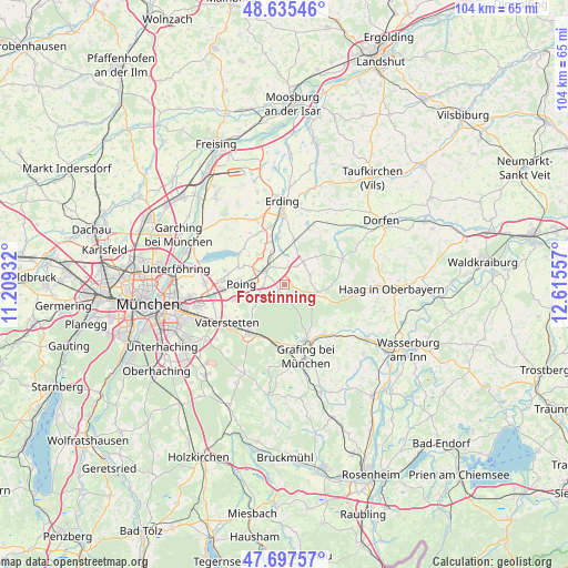
Forstinning GPS coordinates[2]
48° 10' 7.176" North, 11° 54' 44.784" East
| Map corner | latitude | longitude |
|---|---|---|
| Upper-left | 48.63546°, | 11.20932° |
| Center: | 48.16866°, | 11.91244° |
| Lower-right: | 47.69757°, | 12.61557° |
| Map W x H: | 104.3×104.3 km | = 64.8×64.8mi |
| max Lat: | 55.01917° ⇑93.1% North |
| Forstinning: | 48.16866° |
| min Lat: | ⇓6.9% South 47.40724° |
| min Long | Forstinning | max Long |
| 5.92978° | 11.91244° | 14.98853° |
| W 80.5%⇐ | ⇒19.5% E |
Elevation
Elevation of Forstinning is 515 m = 1690 ft, and this is 265.9 m = 872 ft above average elevation for this country.
| Max E: |
1256 m = 4121 ft | 9.9% |
| Forstinning | 515 m 1690 ft | |
| Avg. | 249.1 m = 817 ft | |
Min E: |
-5 m = -16 ft | 90.1% |
See also: Germany elevation on elevation.city.
Geographical zone
Forstinning is located in North temperate zone (between Tropic of Cancer and the Arctic Circle). Distance of this North polar circle is 2045.3 km =1270.9 mi to North.| Distance of | km | miles | from Forstinning |
|---|---|---|---|
| North Pole | 4651.2 | 2890.1 | to North |
| Arctic Circle | 2045.3 | 1270.9 | to North |
| Tropic Cancer | 2749.9 | 1708.7 | to South |
| Equator | 5355.9 | 3328 | to South |


Nearby cities:
15 places around Forstinning: (largest is in red/bold)
• Anzing
4.8 km =3 mi,  246°
246°
• Buch am Buchrain
8 km =5 mi,  49°
49°
• Ebersberg
11.1 km =6.9 mi,  157°
157°
• Finsing
8.4 km =5.2 mi,  308°
308°
• Forstern
5.1 km =3.2 mi,  71°
71°
• Hohenlinden
6.2 km =3.9 mi,  102°
102°
• Kirchseeon
11 km =6.8 mi,  189°
189°
• Markt Schwaben
4 km =2.5 mi, 305°
• Ottenhofen
5.8 km =3.6 mi,  337°
337°
• Pastetten
4.1 km =2.5 mi,  34°
34°
• Pliening
8.8 km =5.5 mi,  289°
289°
• Poing
7 km =4.3 mi,  271°
271°
• Walpertskirchen
11 km =6.8 mi, 25°
• Wörth
8.6 km =5.3 mi,  354°
354°
• Zorneding
11.4 km =7.1 mi,  214°
214°
Sources, notices
• [Note1] Compared only with cities in Germany existing in our database
• [Src1] Map data: © OpenStreetMap contributors (CC-BY-SA)
• [Src2] Other city data from geonames.org with taken over terms of usage.
• [Src3] Geographical zone / Annual Mean Temperature by Robert A. Rohde @ Wikipedia
