Landau an der Isar geodata
Landau an der Isar (Bavaria) is a populated place; located in Germany in Europe/Berlin (GMT+2) time zone. With population of 12,997 people, there are 1237 cities with bigger population in this country. Compared to other cities in Germany, 86.8% of cities are located further ↑North; 89.7% of cities are located further ←West and 68.2% of cities have lower elevation than Landau an der Isar. Note1
Administrative division(s):
- Level 1: Bavaria
- Level 2: Lower Bavaria
- Level 3: Landkreis Dingolfing-Landau
- Level 4: Landau a.d.Isar


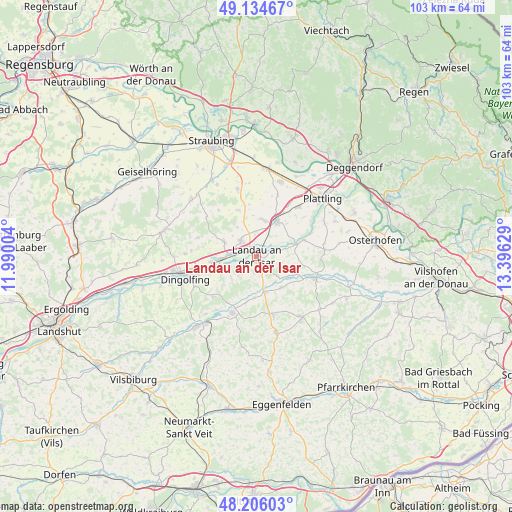
Landau an der Isar GPS coordinates[2]
48° 40' 20.964" North, 12° 41' 35.376" East
| Map corner | latitude | longitude |
|---|---|---|
| Upper-left | 49.13467°, | 11.99004° |
| Center: | 48.67249°, | 12.69316° |
| Lower-right: | 48.20603°, | 13.39629° |
| Map W x H: | 103.3×103.3 km | = 64.2×64.2mi |
| max Lat: | 55.01917° ⇑86.8% North |
| Landau an der Isar: | 48.67249° |
| min Lat: | ⇓13.2% South 47.40724° |
| min Long | Landau an der I | max Long |
| 5.92978° | 12.69316° | 14.98853° |
| W 89.7%⇐ | ⇒10.3% E |
Elevation
Elevation of Landau an der Isar is 344 m = 1129 ft, and this is 94.9 m = 311 ft above average elevation for this country.
| Max E: |
1256 m = 4121 ft | 31.8% |
| Landau an der Isar | 344 m 1129 ft | |
| Avg. | 249.1 m = 817 ft | |
Min E: |
-5 m = -16 ft | 68.2% |
See also: Germany elevation on elevation.city.
Geographical zone
Landau an der Isar is located in North temperate zone (between Tropic of Cancer and the Arctic Circle). Distance of this North polar circle is 1989.3 km =1236.1 mi to North.| Distance of | km | miles | from Landau an der Isar |
|---|---|---|---|
| North Pole | 4595.2 | 2855.3 | to North |
| Arctic Circle | 1989.3 | 1236.1 | to North |
| Tropic Cancer | 2806 | 1743.6 | to South |
| Equator | 5411.9 | 3362.8 | to South |


Nearby cities:
15 places around Landau an der Isar: (largest is in red/bold)
• Arnstorf
15.6 km =9.7 mi,  144°
144°
• Dingolfing
15.1 km =9.4 mi,  257°
257°
• Eichendorf
12.7 km =7.9 mi,  110°
110°
• Gottfrieding
12.2 km =7.6 mi,  251°
251°
• Mamming
6.7 km =4.2 mi, 249°
• Moosthenning
14.4 km =8.9 mi,  271°
271°
• Oberpöring
10.2 km =6.3 mi,  71°
71°
• Oberschneiding
14.2 km =8.8 mi,  344°
344°
• Otzing
13 km =8.1 mi,  40°
40°
• Pilsting
4.4 km =2.7 mi,  315°
315°
• Reisbach
12.4 km =7.7 mi,  202°
202°
• Ruhstorf
14.8 km =9.2 mi,  182°
182°
• Simbach
12.3 km =7.6 mi,  164°
164°
• Wallerfing
13.8 km =8.6 mi,  84°
84°
• Wallersdorf
8.3 km =5.2 mi,  28°
28°
Sources, notices
• [Note1] Compared only with cities in Germany existing in our database
• [Src1] Map data: © OpenStreetMap contributors (CC-BY-SA)
• [Src2] Other city data from geonames.org with taken over terms of usage.
• [Src3] Geographical zone / Annual Mean Temperature by Robert A. Rohde @ Wikipedia
