Ermershausen geodata
Ermershausen (Bavaria) is a seat of a fourth-order administrative division; located in Germany in Europe/Berlin (GMT+2) time zone. With population of 621 people, there are 8713 cities with bigger population in this country. Compared to other cities in Germany, 58.9% of cities are located further ↑North; 61.3% of cities are located further ←West and 67.5% of cities have lower elevation than Ermershausen. Note1
Administrative division(s):
- Level 1: Bavaria
- Level 2: Regierungsbezirk Unterfranken
- Level 3: Landkreis Haßberge
- Level 4: Ermershausen


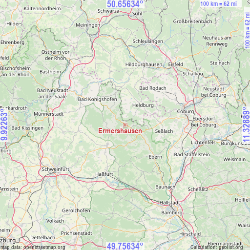
Ermershausen GPS coordinates[2]
50° 12' 30.456" North, 10° 37' 32.736" East
| Map corner | latitude | longitude |
|---|---|---|
| Upper-left | 50.65634°, | 9.92263° |
| Center: | 50.20846°, | 10.62576° |
| Lower-right: | 49.75634°, | 11.32889° |
| Map W x H: | 100.1×100.1 km | = 62.2×62.2mi |
| max Lat: | 55.01917° ⇑58.9% North |
| Ermershausen: | 50.20846° |
| min Lat: | ⇓41.1% South 47.40724° |
| min Long | Ermershausen | max Long |
| 5.92978° | 10.62576° | 14.98853° |
| W 61.3%⇐ | ⇒38.7% E |
Elevation
Elevation of Ermershausen is 339 m = 1112 ft, and this is 89.9 m = 295 ft above average elevation for this country.
| Max E: |
1256 m = 4121 ft | 32.5% |
| Ermershausen | 339 m 1112 ft | |
| Avg. | 249.1 m = 817 ft | |
Min E: |
-5 m = -16 ft | 67.5% |
See also: Germany elevation on elevation.city.
Geographical zone
Ermershausen is located in North temperate zone (between Tropic of Cancer and the Arctic Circle). Distance of this North polar circle is 1818.5 km =1130 mi to North.| Distance of | km | miles | from Ermershausen |
|---|---|---|---|
| North Pole | 4424.4 | 2749.2 | to North |
| Arctic Circle | 1818.5 | 1130 | to North |
| Tropic Cancer | 2976.7 | 1849.6 | to South |
| Equator | 5582.7 | 3468.9 | to South |


Nearby cities:
15 places around Ermershausen: (largest is in red/bold)
• Aidhausen
15.2 km =9.4 mi,  244°
244°
• Bad Königshofen im Grabfeld
15.2 km =9.4 mi,  312°
312°
• Bundorf
7.8 km =4.8 mi,  276°
276°
• Burgpreppach
7.6 km =4.7 mi,  167°
167°
• Gompertshausen
10 km =6.2 mi,  359°
359°
• Hellingen
6.2 km =3.9 mi,  41°
41°
• Herbstadt
16.5 km =10.3 mi,  327°
327°
• Hofheim in Unterfranken
10.8 km =6.7 mi,  222°
222°
• Maroldsweisach
2.8 km =1.7 mi,  120°
120°
• Pfarrweisach
10 km =6.2 mi,  130°
130°
• Seßlach
15.5 km =9.6 mi,  97°
97°
• Sulzfeld
16.7 km =10.4 mi,  289°
289°
• Trappstadt
12.9 km =8 mi,  342°
342°
• Ummerstadt
14.3 km =8.9 mi,  67°
67°
• Westhausen
12.2 km =7.6 mi,  12°
12°
Sources, notices
• [Note1] Compared only with cities in Germany existing in our database
• [Src1] Map data: © OpenStreetMap contributors (CC-BY-SA)
• [Src2] Other city data from geonames.org with taken over terms of usage.
• [Src3] Geographical zone / Annual Mean Temperature by Robert A. Rohde @ Wikipedia
