Osterhofen geodata
Osterhofen (Bavaria) is a populated place; located in Germany in Europe/Berlin (GMT+2) time zone. With population of 11,870 people, there are 1382 cities with bigger population in this country. Compared to other cities in Germany, 86.5% of cities are located further ↑North; 92.4% of cities are located further ←West and 64.7% of cities have lower elevation than Osterhofen. Note1
Administrative division(s):
- Level 1: Bavaria
- Level 2: Lower Bavaria
- Level 3: Landkreis Deggendorf
- Level 4: Osterhofen


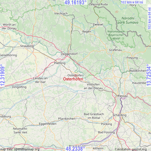
Osterhofen GPS coordinates[2]
48° 42' 0" North, 13° 1' 19.956" East
| Map corner | latitude | longitude |
|---|---|---|
| Upper-left | 49.16193°, | 12.31909° |
| Center: | 48.7°, | 13.02221° |
| Lower-right: | 48.2338°, | 13.72534° |
| Map W x H: | 103.2×103.2 km | = 64.1×64.1mi |
| max Lat: | 55.01917° ⇑86.5% North |
| Osterhofen: | 48.7° |
| min Lat: | ⇓13.5% South 47.40724° |
| min Long | Osterhofen | max Long |
| 5.92978° | 13.02221° | 14.98853° |
| W 92.4%⇐ | ⇒7.6% E |
Elevation
Elevation of Osterhofen is 319 m = 1047 ft, and this is 69.9 m = 229 ft above average elevation for this country.
| Max E: |
1256 m = 4121 ft | 35.3% |
| Osterhofen | 319 m 1047 ft | |
| Avg. | 249.1 m = 817 ft | |
Min E: |
-5 m = -16 ft | 64.7% |
See also: Germany elevation on elevation.city.
Geographical zone
Osterhofen is located in North temperate zone (between Tropic of Cancer and the Arctic Circle). Distance of this North polar circle is 1986.2 km =1234.2 mi to North.| Distance of | km | miles | from Osterhofen |
|---|---|---|---|
| North Pole | 4592.1 | 2853.4 | to North |
| Arctic Circle | 1986.2 | 1234.2 | to North |
| Tropic Cancer | 2809 | 1745.4 | to South |
| Equator | 5414.9 | 3364.7 | to South |


Nearby cities:
15 places around Osterhofen: (largest is in red/bold)
• Aholming
9.1 km =5.7 mi,  295°
295°
• Aldersbach
13.2 km =8.2 mi,  157°
157°
• Auerbach
12.8 km =8 mi,  26°
26°
• Außernzell
13.5 km =8.4 mi,  78°
78°
• Buchhofen
7.2 km =4.5 mi,  267°
267°
• Hengersberg
8.4 km =5.2 mi,  16°
16°
• Hofkirchen
7.5 km =4.7 mi,  108°
108°
• Iggensbach
9.4 km =5.8 mi,  69°
69°
• Künzing
5.8 km =3.6 mi,  129°
129°
• Moos
7.3 km =4.5 mi,  321°
321°
• Niederalteich
7.3 km =4.5 mi,  1°
1°
• Roßbach
12.9 km =8 mi,  210°
210°
• Schöllnach
12.9 km =8 mi,  62°
62°
• Wallerfing
10.6 km =6.6 mi,  260°
260°
• Winzer
4.8 km =3 mi, 57°
Sources, notices
• [Note1] Compared only with cities in Germany existing in our database
• [Src1] Map data: © OpenStreetMap contributors (CC-BY-SA)
• [Src2] Other city data from geonames.org with taken over terms of usage.
• [Src3] Geographical zone / Annual Mean Temperature by Robert A. Rohde @ Wikipedia
