Warendorf geodata
Warendorf (North Rhine-Westphalia) is a seat of a third-order administrative division; located in Germany in Europe/Berlin (GMT+2) time zone. With population of 38,707 people, there are 337 cities with bigger population in this country. Compared to other cities in Germany, 71.7% of cities are located further ↓South; 77.3% of cities are located further →East and 76.4% of cities have higher elevation than Warendorf. Note1
Administrative division(s):
- Level 1: North Rhine-Westphalia
- Level 2: Regierungsbezirk Münster
- Level 3: Kreis Warendorf
- Level 4: Warendorf


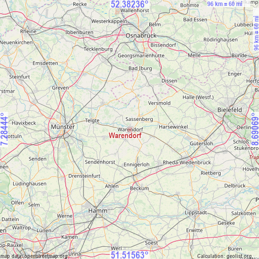
Warendorf GPS coordinates[2]
51° 57' 3.924" North, 7° 59' 15.216" East
| Map corner | latitude | longitude |
|---|---|---|
| Upper-left | 52.38236°, | 7.28444° |
| Center: | 51.95109°, | 7.98756° |
| Lower-right: | 51.51563°, | 8.69069° |
| Map W x H: | 96.4×96.4 km | = 59.9×59.9mi |
| max Lat: | 55.01917° ⇑28.3% North |
| Warendorf: | 51.95109° |
| min Lat: | ⇓71.7% South 47.40724° |
| min Long | Warendorf | max Long |
| 5.92978° | 7.98756° | 14.98853° |
| W 22.7%⇐ | ⇒77.3% E |
Elevation
Elevation of Warendorf is 58 m = 190 ft, and this is 191.1 m = 627 ft below average elevation for this country.
| Max E: |
1256 m = 4121 ft | 76.4% |
| Avg. | 249.1 m = 817 ft | |
| Warendorf | 58 m = 190 ft | |
Min E: |
-5 m = -16 ft | 23.6% |
See also: Germany elevation on elevation.city.
Geographical zone
Warendorf is located in North temperate zone (between Tropic of Cancer and the Arctic Circle). Distance of this North polar circle is 1624.8 km =1009.6 mi to North.| Distance of | km | miles | from Warendorf |
|---|---|---|---|
| North Pole | 4230.6 | 2628.8 | to North |
| Arctic Circle | 1624.8 | 1009.6 | to North |
| Tropic Cancer | 3170.5 | 1970.1 | to South |
| Equator | 5776.4 | 3589.3 | to South |


Nearby cities:
15 places around Warendorf: (largest is in red/bold)
• Ahlen
21.9 km =13.6 mi,  198°
198°
• Bad Laer
17.8 km =11.1 mi,  21°
21°
• Bad Rothenfelde
22.1 km =13.7 mi,  33°
33°
• Beckum
22 km =13.7 mi,  170°
170°
• Beelen
8.8 km =5.5 mi,  106°
106°
• Ennigerloh
12.9 km =8 mi, 166°
• Everswinkel
10 km =6.2 mi,  253°
253°
• Glandorf
14.9 km =9.3 mi,  3°
3°
• Harsewinkel
16.5 km =10.3 mi,  85°
85°
• Oelde
17.5 km =10.9 mi,  141°
141°
• Ostbevern
14 km =8.7 mi,  314°
314°
• Sassenberg
5.8 km =3.6 mi,  38°
38°
• Sendenhorst
16.2 km =10.1 mi,  221°
221°
• Telgte
14.4 km =8.9 mi,  282°
282°
• Versmold
15 km =9.3 mi,  48°
48°
Sources, notices
• [Note1] Compared only with cities in Germany existing in our database
• [Src1] Map data: © OpenStreetMap contributors (CC-BY-SA)
• [Src2] Other city data from geonames.org with taken over terms of usage.
• [Src3] Geographical zone / Annual Mean Temperature by Robert A. Rohde @ Wikipedia
