Wehrheim geodata
Wehrheim (Hesse) is a seat of a fourth-order administrative division; located in Germany in Europe/Berlin (GMT+2) time zone. With population of 9,383 people, there are 1724 cities with bigger population in this country. Compared to other cities in Germany, 56.8% of cities are located further ↑North; 70.5% of cities are located further →East and 63.8% of cities have lower elevation than Wehrheim. Note1
Administrative division(s):
- Level 1: Hesse
- Level 2: Regierungsbezirk Darmstadt
- Level 3: Hochtaunuskreis
- Level 4: Wehrheim


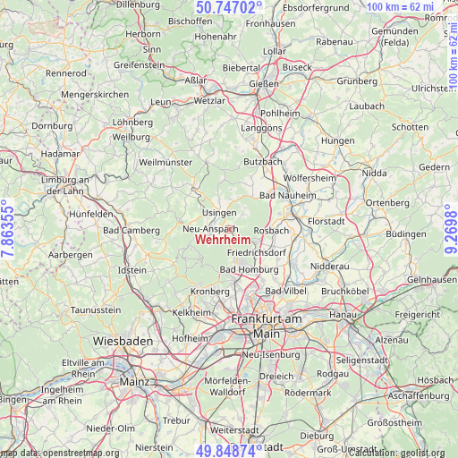
Wehrheim GPS coordinates[2]
50° 18' 0" North, 8° 34' 0.012" East
| Map corner | latitude | longitude |
|---|---|---|
| Upper-left | 50.74702°, | 7.86355° |
| Center: | 50.3°, | 8.56667° |
| Lower-right: | 49.84874°, | 9.2698° |
| Map W x H: | 99.9×99.9 km | = 62.1×62.1mi |
| max Lat: | 55.01917° ⇑56.8% North |
| Wehrheim: | 50.3° |
| min Lat: | ⇓43.2% South 47.40724° |
| min Long | Wehrheim | max Long |
| 5.92978° | 8.56667° | 14.98853° |
| W 29.5%⇐ | ⇒70.5% E |
Elevation
Elevation of Wehrheim is 314 m = 1030 ft, and this is 64.9 m = 213 ft above average elevation for this country.
| Max E: |
1256 m = 4121 ft | 36.2% |
| Wehrheim | 314 m 1030 ft | |
| Avg. | 249.1 m = 817 ft | |
Min E: |
-5 m = -16 ft | 63.8% |
See also: Germany elevation on elevation.city.
Geographical zone
Wehrheim is located in North temperate zone (between Tropic of Cancer and the Arctic Circle). Distance of this North polar circle is 1808.3 km =1123.6 mi to North.| Distance of | km | miles | from Wehrheim |
|---|---|---|---|
| North Pole | 4414.2 | 2742.9 | to North |
| Arctic Circle | 1808.3 | 1123.6 | to North |
| Tropic Cancer | 2986.9 | 1856 | to South |
| Equator | 5592.8 | 3475.2 | to South |


Nearby cities:
15 places around Wehrheim: (largest is in red/bold)
• Bad Homburg vor der Höhe
8.9 km =5.5 mi,  155°
155°
• Bad Nauheim
14.2 km =8.8 mi,  59°
59°
• Friedberg
14.1 km =8.8 mi,  72°
72°
• Friedrichsdorf
7.8 km =4.8 mi,  135°
135°
• Grävenwiesbach
12.7 km =7.9 mi,  322°
322°
• Kronberg
13.2 km =8.2 mi,  193°
193°
• Kronberg Tal
14.1 km =8.8 mi,  198°
198°
• Neu-Anspach
5.1 km =3.2 mi,  291°
291°
• Ober-Mörlen
12 km =7.5 mi,  47°
47°
• Oberems
13.5 km =8.4 mi,  238°
238°
• Oberursel
10.3 km =6.4 mi,  175°
175°
• Rosbach vor der Höhe
8.7 km =5.4 mi,  87°
87°
• Schmitten
9.1 km =5.7 mi,  245°
245°
• Steinbach am Taunus
14.7 km =9.1 mi, 178°
• Usingen
4.5 km =2.8 mi,  331°
331°
Sources, notices
• [Note1] Compared only with cities in Germany existing in our database
• [Src1] Map data: © OpenStreetMap contributors (CC-BY-SA)
• [Src2] Other city data from geonames.org with taken over terms of usage.
• [Src3] Geographical zone / Annual Mean Temperature by Robert A. Rohde @ Wikipedia
