Friedrichsdorf geodata
Friedrichsdorf (Hesse) is a populated place; located in Germany in Europe/Berlin (GMT+2) time zone. With population of 24,435 people, there are 609 cities with bigger population in this country. Compared to other cities in Germany, 58% of cities are located further ↑North; 69.7% of cities are located further →East and 53.2% of cities have higher elevation than Friedrichsdorf. Note1
Administrative division(s):
- Level 1: Hesse
- Level 2: Regierungsbezirk Darmstadt
- Level 3: Hochtaunuskreis
- Level 4: Friedrichsdorf


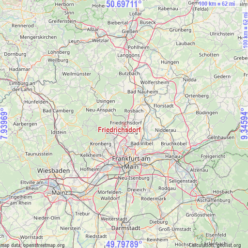
Friedrichsdorf GPS coordinates[2]
50° 14' 58.632" North, 8° 38' 34.116" East
| Map corner | latitude | longitude |
|---|---|---|
| Upper-left | 50.69711°, | 7.93969° |
| Center: | 50.24962°, | 8.64281° |
| Lower-right: | 49.79789°, | 9.34594° |
| Map W x H: | 100×100 km | = 62.1×62.1mi |
| max Lat: | 55.01917° ⇑58% North |
| Friedrichsdorf: | 50.24962° |
| min Lat: | ⇓42% South 47.40724° |
| min Long | Friedrichsdorf | max Long |
| 5.92978° | 8.64281° | 14.98853° |
| W 30.3%⇐ | ⇒69.7% E |
Elevation
Elevation of Friedrichsdorf is 202 m = 663 ft, and this is 47.1 m = 155 ft below average elevation for this country.
| Max E: |
1256 m = 4121 ft | 53.2% |
| Avg. | 249.1 m = 817 ft | |
| Friedrichsdorf | 202 m = 663 ft | |
Min E: |
-5 m = -16 ft | 46.8% |
See also: Germany elevation on elevation.city.
Geographical zone
Friedrichsdorf is located in North temperate zone (between Tropic of Cancer and the Arctic Circle). Distance of this North polar circle is 1813.9 km =1127.1 mi to North.| Distance of | km | miles | from Friedrichsdorf |
|---|---|---|---|
| North Pole | 4419.8 | 2746.3 | to North |
| Arctic Circle | 1813.9 | 1127.1 | to North |
| Tropic Cancer | 2981.3 | 1852.5 | to South |
| Equator | 5587.2 | 3471.7 | to South |


Nearby cities:
15 places around Friedrichsdorf: (largest is in red/bold)
• Bad Homburg vor der Höhe
3.1 km =1.9 mi,  214°
214°
• Bad Vilbel
10.4 km =6.5 mi,  139°
139°
• Eschborn
12.9 km =8 mi,  203°
203°
• Friedberg
12.6 km =7.8 mi,  39°
39°
• Karben
9.4 km =5.8 mi,  103°
103°
• Kronberg
11.2 km =7 mi,  229°
229°
• Kronberg Tal
12.6 km =7.8 mi, 231°
• Neu-Anspach
12.6 km =7.8 mi,  306°
306°
• Niederdorfelden
12.8 km =8 mi,  118°
118°
• Oberursel
6.6 km =4.1 mi,  224°
224°
• Rosbach vor der Höhe
6.8 km =4.2 mi,  29°
29°
• Schwalbach am Taunus
13.5 km =8.4 mi, 215°
• Steinbach am Taunus
10.4 km =6.5 mi, 208°
• Usingen
12.2 km =7.6 mi,  321°
321°
• Wehrheim
7.8 km =4.8 mi, 315°
Sources, notices
• [Note1] Compared only with cities in Germany existing in our database
• [Src1] Map data: © OpenStreetMap contributors (CC-BY-SA)
• [Src2] Other city data from geonames.org with taken over terms of usage.
• [Src3] Geographical zone / Annual Mean Temperature by Robert A. Rohde @ Wikipedia
