Bad Brückenau geodata
Bad Brückenau (Bavaria) is a populated place; located in Germany in Europe/Berlin (GMT+2) time zone. With population of 7,304 people, there are 2116 cities with bigger population in this country. Compared to other cities in Germany, 56.6% of cities are located further ↑North; 52.9% of cities are located further →East and 64% of cities have lower elevation than Bad Brückenau. Note1
Administrative division(s):
- Level 1: Bavaria
- Level 2: Regierungsbezirk Unterfranken
- Level 3: Landkreis Bad Kissingen
- Level 4: Bad Brückenau


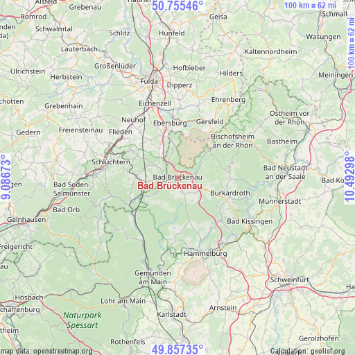
Bad Brückenau GPS coordinates[2]
50° 18' 30.708" North, 9° 47' 23.46" East
| Map corner | latitude | longitude |
|---|---|---|
| Upper-left | 50.75546°, | 9.08673° |
| Center: | 50.30853°, | 9.78985° |
| Lower-right: | 49.85735°, | 10.49298° |
| Map W x H: | 99.9×99.9 km | = 62.1×62.1mi |
| max Lat: | 55.01917° ⇑56.6% North |
| Bad Brückenau: | 50.30853° |
| min Lat: | ⇓43.4% South 47.40724° |
| min Long | Bad Brückenau | max Long |
| 5.92978° | 9.78985° | 14.98853° |
| W 47.1%⇐ | ⇒52.9% E |
Elevation
Elevation of Bad Brückenau is 315 m = 1033 ft, and this is 65.9 m = 216 ft above average elevation for this country.
| Max E: |
1256 m = 4121 ft | 36% |
| Bad Brückenau | 315 m 1033 ft | |
| Avg. | 249.1 m = 817 ft | |
Min E: |
-5 m = -16 ft | 64% |
See also: Germany elevation on elevation.city.
Geographical zone
Bad Brückenau is located in North temperate zone (between Tropic of Cancer and the Arctic Circle). Distance of this North polar circle is 1807.4 km =1123.1 mi to North.| Distance of | km | miles | from Bad Brückenau |
|---|---|---|---|
| North Pole | 4413.3 | 2742.3 | to North |
| Arctic Circle | 1807.4 | 1123.1 | to North |
| Tropic Cancer | 2987.9 | 1856.6 | to South |
| Equator | 5593.8 | 3475.8 | to South |


Nearby cities:
15 places around Bad Brückenau: (largest is in red/bold)
• Burkardroth
14.9 km =9.3 mi,  106°
106°
• Geroda
8.1 km =5 mi, 112°
• Gersfeld
18.2 km =11.3 mi,  29°
29°
• Kalbach
13.1 km =8.1 mi,  324°
324°
• Mittelsinn
17.8 km =11.1 mi,  223°
223°
• Motten
9.8 km =6.1 mi,  352°
352°
• Oberleichtersbach
2.9 km =1.8 mi,  165°
165°
• Obersinn
16.6 km =10.3 mi,  228°
228°
• Oberthulba
17.1 km =10.6 mi,  135°
135°
• Riedenberg
5.2 km =3.2 mi,  75°
75°
• Sandberg
16.1 km =10 mi,  74°
74°
• Schondra
6.9 km =4.3 mi,  130°
130°
• Wartmannsroth
15.8 km =9.8 mi,  181°
181°
• Wildflecken
11.5 km =7.1 mi,  48°
48°
• Zeitlofs
9.8 km =6.1 mi,  238°
238°
Sources, notices
• [Note1] Compared only with cities in Germany existing in our database
• [Src1] Map data: © OpenStreetMap contributors (CC-BY-SA)
• [Src2] Other city data from geonames.org with taken over terms of usage.
• [Src3] Geographical zone / Annual Mean Temperature by Robert A. Rohde @ Wikipedia
