Nordwalde geodata
Nordwalde (North Rhine-Westphalia) is a seat of a fourth-order administrative division; located in Germany in Europe/Berlin (GMT+2) time zone. With population of 9,453 people, there are 1711 cities with bigger population in this country. Compared to other cities in Germany, 72.8% of cities are located further ↓South; 87.4% of cities are located further →East and 79.4% of cities have higher elevation than Nordwalde. Note1
Administrative division(s):
- Level 1: North Rhine-Westphalia
- Level 2: Regierungsbezirk Münster
- Level 3: Kreis Steinfurt
- Level 4: Nordwalde


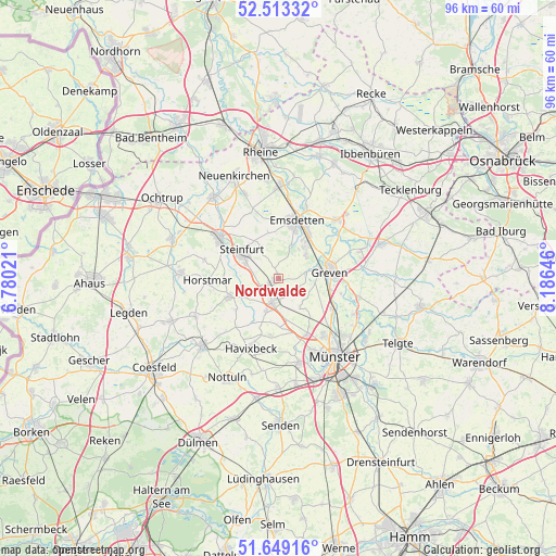
Nordwalde GPS coordinates[2]
52° 4' 59.988" North, 7° 28' 59.988" East
| Map corner | latitude | longitude |
|---|---|---|
| Upper-left | 52.51332°, | 6.78021° |
| Center: | 52.08333°, | 7.48333° |
| Lower-right: | 51.64916°, | 8.18646° |
| Map W x H: | 96.1×96.1 km | = 59.7×59.7mi |
| max Lat: | 55.01917° ⇑27.2% North |
| Nordwalde: | 52.08333° |
| min Lat: | ⇓72.8% South 47.40724° |
| min Long | Nordwalde | max Long |
| 5.92978° | 7.48333° | 14.98853° |
| W 12.6%⇐ | ⇒87.4% E |
Elevation
Elevation of Nordwalde is 48 m = 157 ft, and this is 201.1 m = 660 ft below average elevation for this country.
| Max E: |
1256 m = 4121 ft | 79.4% |
| Avg. | 249.1 m = 817 ft | |
| Nordwalde | 48 m = 157 ft | |
Min E: |
-5 m = -16 ft | 20.6% |
See also: Germany elevation on elevation.city.
Geographical zone
Nordwalde is located in North temperate zone (between Tropic of Cancer and the Arctic Circle). Distance of this North polar circle is 1610.1 km =1000.5 mi to North.| Distance of | km | miles | from Nordwalde |
|---|---|---|---|
| North Pole | 4215.9 | 2619.6 | to North |
| Arctic Circle | 1610.1 | 1000.5 | to North |
| Tropic Cancer | 3185.2 | 1979.2 | to South |
| Equator | 5791.1 | 3598.4 | to South |


Nearby cities:
15 places around Nordwalde: (largest is in red/bold)
• Altenberge
3.9 km =2.4 mi,  197°
197°
• Billerbeck
17.5 km =10.9 mi,  228°
228°
• Emsdetten
10.5 km =6.5 mi,  16°
16°
• Greven
7.6 km =4.7 mi,  81°
81°
• Havixbeck
12 km =7.5 mi, 202°
• Horstmar
12.2 km =7.6 mi,  268°
268°
• Ladbergen
19 km =11.8 mi,  73°
73°
• Laer
9.1 km =5.7 mi,  250°
250°
• Münster
16.6 km =10.3 mi,  144°
144°
• Neuenkirchen
19.5 km =12.1 mi,  337°
337°
• Nottuln
19 km =11.8 mi,  208°
208°
• Saerbeck
14.4 km =8.9 mi,  45°
45°
• Schöppingen
17.2 km =10.7 mi,  276°
276°
• Steinfurt
12.5 km =7.8 mi,  306°
306°
• Wettringen
18 km =11.2 mi,  321°
321°
Sources, notices
• [Note1] Compared only with cities in Germany existing in our database
• [Src1] Map data: © OpenStreetMap contributors (CC-BY-SA)
• [Src2] Other city data from geonames.org with taken over terms of usage.
• [Src3] Geographical zone / Annual Mean Temperature by Robert A. Rohde @ Wikipedia
