Laer geodata
Laer (North Rhine-Westphalia) is a seat of a fourth-order administrative division; located in Germany in Europe/Berlin (GMT+2) time zone. With population of 6,325 people, there are 2355 cities with bigger population in this country. Compared to other cities in Germany, 72.6% of cities are located further ↓South; 89.1% of cities are located further →East and 72% of cities have higher elevation than Laer. Note1
Administrative division(s):
- Level 1: North Rhine-Westphalia
- Level 2: Regierungsbezirk Münster
- Level 3: Kreis Steinfurt
- Level 4: Laer


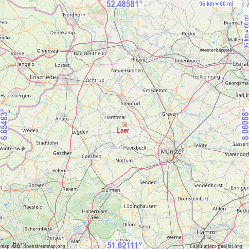
Laer GPS coordinates[2]
52° 3' 19.98" North, 7° 21' 27.9" East
| Map corner | latitude | longitude |
|---|---|---|
| Upper-left | 52.48581°, | 6.65463° |
| Center: | 52.05555°, | 7.35775° |
| Lower-right: | 51.62111°, | 8.06088° |
| Map W x H: | 96.1×96.1 km | = 59.7×59.7mi |
| max Lat: | 55.01917° ⇑27.4% North |
| Laer: | 52.05555° |
| min Lat: | ⇓72.6% South 47.40724° |
| min Long | Laer | max Long |
| 5.92978° | 7.35775° | 14.98853° |
| W 10.9%⇐ | ⇒89.1% E |
Elevation
Elevation of Laer is 78 m = 256 ft, and this is 171.1 m = 561 ft below average elevation for this country.
| Max E: |
1256 m = 4121 ft | 72% |
| Avg. | 249.1 m = 817 ft | |
| Laer | 78 m = 256 ft | |
Min E: |
-5 m = -16 ft | 28% |
See also: Germany elevation on elevation.city.
Geographical zone
Laer is located in North temperate zone (between Tropic of Cancer and the Arctic Circle). Distance of this North polar circle is 1613.1 km =1002.3 mi to North.| Distance of | km | miles | from Laer |
|---|---|---|---|
| North Pole | 4219 | 2621.6 | to North |
| Arctic Circle | 1613.1 | 1002.3 | to North |
| Tropic Cancer | 3182.1 | 1977.3 | to South |
| Equator | 5788 | 3596.5 | to South |


Nearby cities:
15 places around Laer: (largest is in red/bold)
• Altenberge
7.5 km =4.7 mi,  94°
94°
• Billerbeck
9.7 km =6 mi,  207°
207°
• Coesfeld
18 km =11.2 mi,  226°
226°
• Emsdetten
17.5 km =10.9 mi,  41°
41°
• Greven
16.7 km =10.4 mi,  75°
75°
• Havixbeck
9 km =5.6 mi,  153°
153°
• Heek
18.9 km =11.7 mi,  291°
291°
• Horstmar
4.6 km =2.9 mi,  308°
308°
• Legden
17.8 km =11.1 mi,  262°
262°
• Metelen
14 km =8.7 mi, 314°
• Nordwalde
9.1 km =5.7 mi,  70°
70°
• Nottuln
13.6 km =8.5 mi,  182°
182°
• Schöppingen
9.8 km =6.1 mi,  300°
300°
• Steinfurt
10.6 km =6.6 mi,  352°
352°
• Wettringen
17.3 km =10.7 mi, 351°
Sources, notices
• [Note1] Compared only with cities in Germany existing in our database
• [Src1] Map data: © OpenStreetMap contributors (CC-BY-SA)
• [Src2] Other city data from geonames.org with taken over terms of usage.
• [Src3] Geographical zone / Annual Mean Temperature by Robert A. Rohde @ Wikipedia
