Horstmar geodata
Horstmar (North Rhine-Westphalia) is a populated place; located in Germany in Europe/Berlin (GMT+2) time zone. With population of 6,822 people, there are 2227 cities with bigger population in this country. Compared to other cities in Germany, 72.8% of cities are located further ↓South; 89.8% of cities are located further →East and 67.6% of cities have higher elevation than Horstmar. Note1
Administrative division(s):
- Level 1: North Rhine-Westphalia
- Level 2: Regierungsbezirk Münster
- Level 3: Kreis Steinfurt
- Level 4: Horstmar


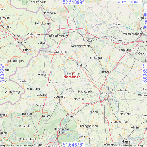
Horstmar GPS coordinates[2]
52° 4' 51.528" North, 7° 18' 19.404" East
| Map corner | latitude | longitude |
|---|---|---|
| Upper-left | 52.51099°, | 6.60226° |
| Center: | 52.08098°, | 7.30539° |
| Lower-right: | 51.64678°, | 8.00851° |
| Map W x H: | 96.1×96.1 km | = 59.7×59.7mi |
| max Lat: | 55.01917° ⇑27.2% North |
| Horstmar: | 52.08098° |
| min Lat: | ⇓72.8% South 47.40724° |
| min Long | Horstmar | max Long |
| 5.92978° | 7.30539° | 14.98853° |
| W 10.2%⇐ | ⇒89.8% E |
Elevation
Elevation of Horstmar is 104 m = 341 ft, and this is 145.1 m = 476 ft below average elevation for this country.
| Max E: |
1256 m = 4121 ft | 67.6% |
| Avg. | 249.1 m = 817 ft | |
| Horstmar | 104 m = 341 ft | |
Min E: |
-5 m = -16 ft | 32.4% |
See also: Germany elevation on elevation.city.
Geographical zone
Horstmar is located in North temperate zone (between Tropic of Cancer and the Arctic Circle). Distance of this North polar circle is 1610.3 km =1000.6 mi to North.| Distance of | km | miles | from Horstmar |
|---|---|---|---|
| North Pole | 4216.2 | 2619.8 | to North |
| Arctic Circle | 1610.3 | 1000.6 | to North |
| Tropic Cancer | 3184.9 | 1979 | to South |
| Equator | 5790.9 | 3598.3 | to South |


Nearby cities:
15 places around Horstmar: (largest is in red/bold)
• Altenberge
11.5 km =7.1 mi,  107°
107°
• Billerbeck
11.5 km =7.1 mi,  184°
184°
• Coesfeld
17.9 km =11.1 mi,  211°
211°
• Emsdetten
18.3 km =11.4 mi,  55°
55°
• Havixbeck
13.3 km =8.3 mi,  144°
144°
• Heek
14.6 km =9.1 mi,  285°
285°
• Laer
4.6 km =2.9 mi,  128°
128°
• Legden
15 km =9.3 mi,  249°
249°
• Metelen
9.5 km =5.9 mi,  318°
318°
• Nordwalde
12.2 km =7.6 mi,  88°
88°
• Nottuln
16.7 km =10.4 mi,  169°
169°
• Ochtrup
16.2 km =10.1 mi,  330°
330°
• Schöppingen
5.4 km =3.4 mi, 293°
• Steinfurt
8 km =5 mi,  15°
15°
• Wettringen
14.3 km =8.9 mi,  3°
3°
Sources, notices
• [Note1] Compared only with cities in Germany existing in our database
• [Src1] Map data: © OpenStreetMap contributors (CC-BY-SA)
• [Src2] Other city data from geonames.org with taken over terms of usage.
• [Src3] Geographical zone / Annual Mean Temperature by Robert A. Rohde @ Wikipedia
