Greven geodata
Greven (North Rhine-Westphalia) is a populated place; located in Germany in Europe/Berlin (GMT+2) time zone. With population of 35,080 people, there are 382 cities with bigger population in this country. Compared to other cities in Germany, 72.9% of cities are located further ↓South; 85.1% of cities are located further →East and 80.6% of cities have higher elevation than Greven. Note1
Administrative division(s):
- Level 1: North Rhine-Westphalia
- Level 2: Regierungsbezirk Münster
- Level 3: Kreis Steinfurt
- Level 4: Greven


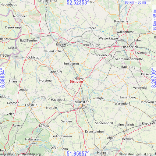
Greven GPS coordinates[2]
52° 5' 37.104" North, 7° 35' 38.256" East
| Map corner | latitude | longitude |
|---|---|---|
| Upper-left | 52.52353°, | 6.89084° |
| Center: | 52.09364°, | 7.59396° |
| Lower-right: | 51.65957°, | 8.29709° |
| Map W x H: | 96.1×96.1 km | = 59.7×59.7mi |
| max Lat: | 55.01917° ⇑27.1% North |
| Greven: | 52.09364° |
| min Lat: | ⇓72.9% South 47.40724° |
| min Long | Greven | max Long |
| 5.92978° | 7.59396° | 14.98853° |
| W 14.9%⇐ | ⇒85.1% E |
Elevation
Elevation of Greven is 45 m = 148 ft, and this is 204.1 m = 670 ft below average elevation for this country.
| Max E: |
1256 m = 4121 ft | 80.6% |
| Avg. | 249.1 m = 817 ft | |
| Greven | 45 m = 148 ft | |
Min E: |
-5 m = -16 ft | 19.4% |
See also: Germany elevation on elevation.city.
Geographical zone
Greven is located in North temperate zone (between Tropic of Cancer and the Arctic Circle). Distance of this North polar circle is 1608.9 km =999.7 mi to North.| Distance of | km | miles | from Greven |
|---|---|---|---|
| North Pole | 4214.8 | 2619 | to North |
| Arctic Circle | 1608.9 | 999.7 | to North |
| Tropic Cancer | 3186.4 | 1979.9 | to South |
| Equator | 5792.3 | 3599.2 | to South |


Nearby cities:
15 places around Greven: (largest is in red/bold)
• Altenberge
10 km =6.2 mi,  240°
240°
• Birgte
17.5 km =10.9 mi,  12°
12°
• Emsdetten
10 km =6.2 mi,  333°
333°
• Havixbeck
17.2 km =10.7 mi,  224°
224°
• Horstmar
19.8 km =12.3 mi,  265°
265°
• Ladbergen
11.5 km =7.1 mi,  67°
67°
• Laer
16.7 km =10.4 mi,  255°
255°
• Lengerich
20.9 km =13 mi,  60°
60°
• Münster
14.8 km =9.2 mi,  171°
171°
• Nordwalde
7.6 km =4.7 mi, 261°
• Ostbevern
18 km =11.2 mi,  109°
109°
• Saerbeck
9.3 km =5.8 mi,  17°
17°
• Steinfurt
18.7 km =11.6 mi,  289°
289°
• Tecklenburg
20.5 km =12.7 mi,  46°
46°
• Telgte
18.1 km =11.2 mi,  134°
134°
Sources, notices
• [Note1] Compared only with cities in Germany existing in our database
• [Src1] Map data: © OpenStreetMap contributors (CC-BY-SA)
• [Src2] Other city data from geonames.org with taken over terms of usage.
• [Src3] Geographical zone / Annual Mean Temperature by Robert A. Rohde @ Wikipedia
