Niederaula geodata
Niederaula (Hesse) is a seat of a fourth-order administrative division; located in Germany in Europe/Berlin (GMT+2) time zone. With population of 5,526 people, there are 2619 cities with bigger population in this country. Compared to other cities in Germany, 54.1% of cities are located further ↓South; 56.2% of cities are located further →East and 51.8% of cities have higher elevation than Niederaula. Note1
Administrative division(s):
- Level 1: Hesse
- Level 2: Regierungsbezirk Kassel
- Level 3: Landkreis Hersfeld-Rotenburg
- Level 4: Niederaula


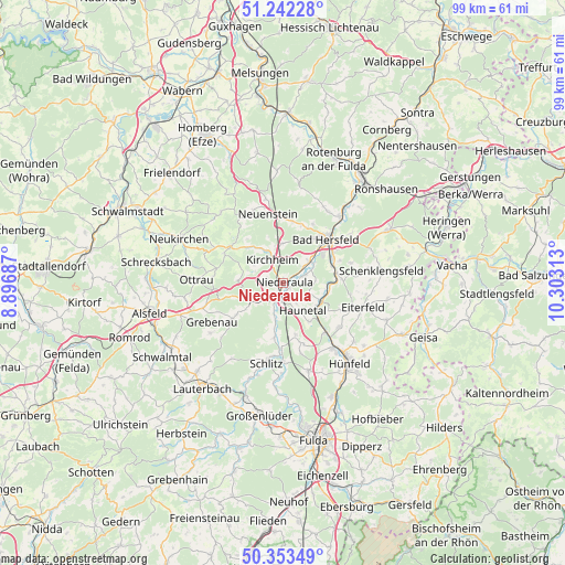
Niederaula GPS coordinates[2]
50° 48' 0" North, 9° 36' 0" East
| Map corner | latitude | longitude |
|---|---|---|
| Upper-left | 51.24228°, | 8.89687° |
| Center: | 50.8°, | 9.6° |
| Lower-right: | 50.35349°, | 10.30313° |
| Map W x H: | 98.8×98.8 km | = 61.4×61.4mi |
| max Lat: | 55.01917° ⇑45.9% North |
| Niederaula: | 50.8° |
| min Lat: | ⇓54.1% South 47.40724° |
| min Long | Niederaula | max Long |
| 5.92978° | 9.6° | 14.98853° |
| W 43.8%⇐ | ⇒56.2% E |
Elevation
Elevation of Niederaula is 213 m = 699 ft, and this is 36.1 m = 118 ft below average elevation for this country.
| Max E: |
1256 m = 4121 ft | 51.8% |
| Avg. | 249.1 m = 817 ft | |
| Niederaula | 213 m = 699 ft | |
Min E: |
-5 m = -16 ft | 48.2% |
See also: Germany elevation on elevation.city.
Geographical zone
Niederaula is located in North temperate zone (between Tropic of Cancer and the Arctic Circle). Distance of this North polar circle is 1752.7 km =1089.1 mi to North.| Distance of | km | miles | from Niederaula |
|---|---|---|---|
| North Pole | 4358.6 | 2708.3 | to North |
| Arctic Circle | 1752.7 | 1089.1 | to North |
| Tropic Cancer | 3042.5 | 1890.5 | to South |
| Equator | 5648.4 | 3509.8 | to South |


Nearby cities:
15 places around Niederaula: (largest is in red/bold)
• Bad Hersfeld
11.1 km =6.9 mi,  43°
43°
• Bad Salzschlirf
20.6 km =12.8 mi,  198°
198°
• Burghaun
14.4 km =8.9 mi,  142°
142°
• Eiterfeld
14.5 km =9 mi,  104°
104°
• Friedewald
20.9 km =13 mi,  63°
63°
• Grebenau
11 km =6.8 mi,  234°
234°
• Hünfeld
17.8 km =11.1 mi, 138°
• Kirchheim
4.4 km =2.7 mi,  327°
327°
• Neukirchen
19.4 km =12.1 mi,  293°
293°
• Oberaula
10.9 km =6.8 mi,  300°
300°
• Ottrau
15.1 km =9.4 mi,  272°
272°
• Schenklengsfeld
17.7 km =11 mi,  83°
83°
• Schlitz
14.3 km =8.9 mi,  191°
191°
• Schwarzenborn
16.3 km =10.1 mi,  318°
318°
• Seigertshausen
21 km =13 mi,  306°
306°
Sources, notices
• [Note1] Compared only with cities in Germany existing in our database
• [Src1] Map data: © OpenStreetMap contributors (CC-BY-SA)
• [Src2] Other city data from geonames.org with taken over terms of usage.
• [Src3] Geographical zone / Annual Mean Temperature by Robert A. Rohde @ Wikipedia
