Bad Salzschlirf geodata
Bad Salzschlirf (Hesse) is a seat of a fourth-order administrative division; located in Germany in Europe/Berlin (GMT+2) time zone. With population of 3,204 people, there are 3824 cities with bigger population in this country. Compared to other cities in Germany, 50.1% of cities are located further ↓South; 57.7% of cities are located further →East and 53.9% of cities have lower elevation than Bad Salzschlirf. Note1
Administrative division(s):
- Level 1: Hesse
- Level 2: Regierungsbezirk Kassel
- Level 3: Landkreis Fulda
- Level 4: Bad Salzschlirf


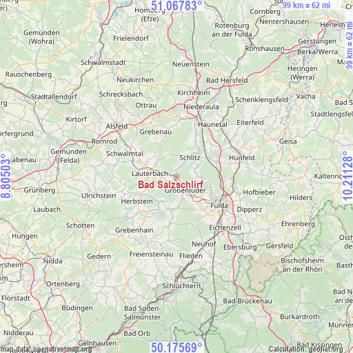
Bad Salzschlirf GPS coordinates[2]
50° 37' 25.968" North, 9° 30' 29.34" East
| Map corner | latitude | longitude |
|---|---|---|
| Upper-left | 51.06783°, | 8.80503° |
| Center: | 50.62388°, | 9.50815° |
| Lower-right: | 50.17569°, | 10.21128° |
| Map W x H: | 99.2×99.2 km | = 61.6×61.6mi |
| max Lat: | 55.01917° ⇑49.9% North |
| Bad Salzschlirf: | 50.62388° |
| min Lat: | ⇓50.1% South 47.40724° |
| min Long | Bad Salzschlirf | max Long |
| 5.92978° | 9.50815° | 14.98853° |
| W 42.3%⇐ | ⇒57.7% E |
Elevation
Elevation of Bad Salzschlirf is 251 m = 823 ft, and this is 1.9 m = 6 ft above average elevation for this country.
| Max E: |
1256 m = 4121 ft | 46.1% |
| Bad Salzschlirf | 251 m 823 ft | |
| Avg. | 249.1 m = 817 ft | |
Min E: |
-5 m = -16 ft | 53.9% |
See also: Germany elevation on elevation.city.
Geographical zone
Bad Salzschlirf is located in North temperate zone (between Tropic of Cancer and the Arctic Circle). Distance of this North polar circle is 1772.3 km =1101.3 mi to North.| Distance of | km | miles | from Bad Salzschlirf |
|---|---|---|---|
| North Pole | 4378.2 | 2720.5 | to North |
| Arctic Circle | 1772.3 | 1101.3 | to North |
| Tropic Cancer | 3022.9 | 1878.3 | to South |
| Equator | 5628.8 | 3497.6 | to South |


Nearby cities:
15 places around Bad Salzschlirf: (largest is in red/bold)
• Burghaun
17.3 km =10.7 mi,  61°
61°
• Eichenzell
19.5 km =12.1 mi,  137°
137°
• Fulda
14.3 km =8.9 mi,  124°
124°
• Grebenau
13.4 km =8.3 mi,  349°
349°
• Grebenhain
19.2 km =11.9 mi,  218°
218°
• Großenlüder
4.2 km =2.6 mi,  145°
145°
• Herbstein
13.4 km =8.3 mi,  238°
238°
• Hosenfeld
13.4 km =8.3 mi,  188°
188°
• Hünfeld
19.3 km =12 mi,  71°
71°
• Künzell
17.3 km =10.7 mi, 120°
• Lauterbach
7.9 km =4.9 mi,  279°
279°
• Lautertal
16.5 km =10.3 mi,  254°
254°
• Neuhof
20.5 km =12.7 mi,  157°
157°
• Niederaula
20.6 km =12.8 mi,  18°
18°
• Schlitz
6.7 km =4.2 mi,  33°
33°
Sources, notices
• [Note1] Compared only with cities in Germany existing in our database
• [Src1] Map data: © OpenStreetMap contributors (CC-BY-SA)
• [Src2] Other city data from geonames.org with taken over terms of usage.
• [Src3] Geographical zone / Annual Mean Temperature by Robert A. Rohde @ Wikipedia
