Bad Hersfeld geodata
Bad Hersfeld (Hesse) is a seat of a third-order administrative division; located in Germany in Europe/Berlin (GMT+2) time zone. With population of 30,725 people, there are 453 cities with bigger population in this country. Compared to other cities in Germany, 55.6% of cities are located further ↓South; 54.2% of cities are located further →East and 52.3% of cities have higher elevation than Bad Hersfeld. Note1
Administrative division(s):
- Level 1: Hesse
- Level 2: Regierungsbezirk Kassel
- Level 3: Landkreis Hersfeld-Rotenburg
- Level 4: Bad Hersfeld, Kreisstadt


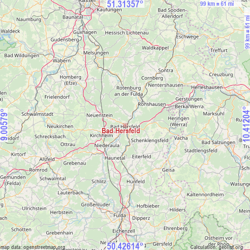
Bad Hersfeld GPS coordinates[2]
50° 52' 19.092" North, 9° 42' 32.076" East
| Map corner | latitude | longitude |
|---|---|---|
| Upper-left | 51.31357°, | 9.00579° |
| Center: | 50.87197°, | 9.70891° |
| Lower-right: | 50.42614°, | 10.41204° |
| Map W x H: | 98.7×98.7 km | = 61.3×61.3mi |
| max Lat: | 55.01917° ⇑44.4% North |
| Bad Hersfeld: | 50.87197° |
| min Lat: | ⇓55.6% South 47.40724° |
| min Long | Bad Hersfeld | max Long |
| 5.92978° | 9.70891° | 14.98853° |
| W 45.8%⇐ | ⇒54.2% E |
Elevation
Elevation of Bad Hersfeld is 209 m = 686 ft, and this is 40.1 m = 132 ft below average elevation for this country.
| Max E: |
1256 m = 4121 ft | 52.3% |
| Avg. | 249.1 m = 817 ft | |
| Bad Hersfeld | 209 m = 686 ft | |
Min E: |
-5 m = -16 ft | 47.7% |
See also: Germany elevation on elevation.city.
Geographical zone
Bad Hersfeld is located in North temperate zone (between Tropic of Cancer and the Arctic Circle). Distance of this North polar circle is 1744.7 km =1084.1 mi to North.| Distance of | km | miles | from Bad Hersfeld |
|---|---|---|---|
| North Pole | 4350.6 | 2703.3 | to North |
| Arctic Circle | 1744.7 | 1084.1 | to North |
| Tropic Cancer | 3050.5 | 1895.5 | to South |
| Equator | 5656.4 | 3514.7 | to South |


Nearby cities:
15 places around Bad Hersfeld: (largest is in red/bold)
• Alheim
18.2 km =11.3 mi,  350°
350°
• Bebra
12.9 km =8 mi,  28°
28°
• Breitenbach
10.7 km =6.6 mi, 28°
• Burghaun
19.5 km =12.1 mi,  176°
176°
• Eiterfeld
13.3 km =8.3 mi,  151°
151°
• Friedewald
11.1 km =6.9 mi,  83°
83°
• Großensee
19.3 km =12 mi,  69°
69°
• Kirchheim
10.9 km =6.8 mi,  246°
246°
• Niederaula
11.1 km =6.9 mi,  223°
223°
• Oberaula
17.2 km =10.7 mi,  261°
261°
• Ronshausen
13.2 km =8.2 mi,  48°
48°
• Rotenburg an der Fulda
13.8 km =8.6 mi,  5°
5°
• Schenklengsfeld
11.7 km =7.3 mi,  121°
121°
• Schwarzenborn
18.9 km =11.7 mi,  282°
282°
• Unterbreizbach
20.2 km =12.6 mi,  107°
107°
Sources, notices
• [Note1] Compared only with cities in Germany existing in our database
• [Src1] Map data: © OpenStreetMap contributors (CC-BY-SA)
• [Src2] Other city data from geonames.org with taken over terms of usage.
• [Src3] Geographical zone / Annual Mean Temperature by Robert A. Rohde @ Wikipedia
