Schwarzenborn geodata
Schwarzenborn (Hesse) is a populated place; located in Germany in Europe/Berlin (GMT+2) time zone. With population of 1,251 people, there are 6438 cities with bigger population in this country. Compared to other cities in Germany, 56.3% of cities are located further ↓South; 58.7% of cities are located further →East and 86.8% of cities have lower elevation than Schwarzenborn. Note1
Administrative division(s):
- Level 1: Hesse
- Level 2: Regierungsbezirk Kassel
- Level 3: Schwalm-Eder-Kreis
- Level 4: Schwarzenborn


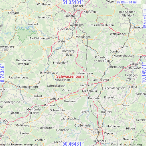
Schwarzenborn GPS coordinates[2]
50° 54' 35.172" North, 9° 26' 47.688" East
| Map corner | latitude | longitude |
|---|---|---|
| Upper-left | 51.35101°, | 8.74346° |
| Center: | 50.90977°, | 9.44658° |
| Lower-right: | 50.46431°, | 10.14971° |
| Map W x H: | 98.6×98.6 km | = 61.3×61.3mi |
| max Lat: | 55.01917° ⇑43.7% North |
| Schwarzenborn: | 50.90977° |
| min Lat: | ⇓56.3% South 47.40724° |
| min Long | Schwarzenborn | max Long |
| 5.92978° | 9.44658° | 14.98853° |
| W 41.3%⇐ | ⇒58.7% E |
Elevation
Elevation of Schwarzenborn is 484 m = 1588 ft, and this is 234.9 m = 771 ft above average elevation for this country.
| Max E: |
1256 m = 4121 ft | 13.2% |
| Schwarzenborn | 484 m 1588 ft | |
| Avg. | 249.1 m = 817 ft | |
Min E: |
-5 m = -16 ft | 86.8% |
See also: Germany elevation on elevation.city.
Geographical zone
Schwarzenborn is located in North temperate zone (between Tropic of Cancer and the Arctic Circle). Distance of this North polar circle is 1740.5 km =1081.5 mi to North.| Distance of | km | miles | from Schwarzenborn |
|---|---|---|---|
| North Pole | 4346.4 | 2700.7 | to North |
| Arctic Circle | 1740.5 | 1081.5 | to North |
| Tropic Cancer | 3054.7 | 1898.1 | to South |
| Equator | 5660.6 | 3517.3 | to South |


Nearby cities:
15 places around Schwarzenborn: (largest is in red/bold)
• Bad Hersfeld
18.9 km =11.7 mi,  102°
102°
• Borken
18.8 km =11.7 mi,  322°
322°
• Frielendorf
11 km =6.8 mi,  307°
307°
• Grebenau
18.7 km =11.6 mi,  174°
174°
• Homberg
13.7 km =8.5 mi,  347°
347°
• Kirchheim
12 km =7.5 mi,  135°
135°
• Neukirchen
8.3 km =5.2 mi,  237°
237°
• Niederaula
16.3 km =10.1 mi, 138°
• Oberaula
6.8 km =4.2 mi, 168°
• Ottrau
12.3 km =7.6 mi,  200°
200°
• Riebelsdorf
10.3 km =6.4 mi,  250°
250°
• Schrecksbach
14.3 km =8.9 mi,  233°
233°
• Schwalmstadt
16.3 km =10.1 mi,  279°
279°
• Seigertshausen
6.2 km =3.9 mi,  271°
271°
• Willingshausen
18.5 km =11.5 mi, 248°
Sources, notices
• [Note1] Compared only with cities in Germany existing in our database
• [Src1] Map data: © OpenStreetMap contributors (CC-BY-SA)
• [Src2] Other city data from geonames.org with taken over terms of usage.
• [Src3] Geographical zone / Annual Mean Temperature by Robert A. Rohde @ Wikipedia
