Telgte geodata
Telgte (North Rhine-Westphalia) is a populated place; located in Germany in Europe/Berlin (GMT+2) time zone. With population of 19,389 people, there are 802 cities with bigger population in this country. Compared to other cities in Germany, 72% of cities are located further ↓South; 81.3% of cities are located further →East and 77.3% of cities have higher elevation than Telgte. Note1
Administrative division(s):
- Level 1: North Rhine-Westphalia
- Level 2: Regierungsbezirk Münster
- Level 3: Kreis Warendorf
- Level 4: Telgte


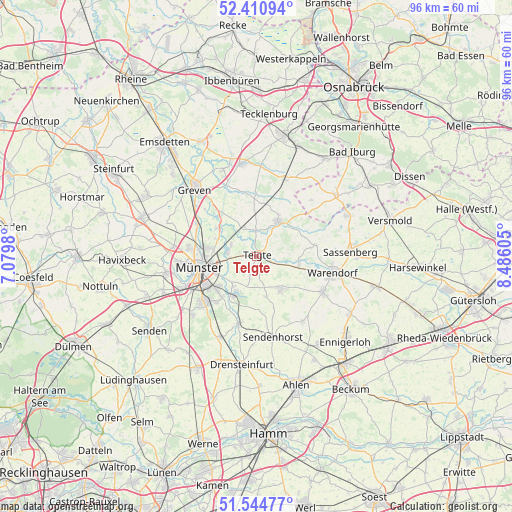
Telgte GPS coordinates[2]
51° 58' 47.82" North, 7° 46' 58.548" East
| Map corner | latitude | longitude |
|---|---|---|
| Upper-left | 52.41094°, | 7.0798° |
| Center: | 51.97995°, | 7.78293° |
| Lower-right: | 51.54477°, | 8.48605° |
| Map W x H: | 96.3×96.3 km | = 59.8×59.8mi |
| max Lat: | 55.01917° ⇑28% North |
| Telgte: | 51.97995° |
| min Lat: | ⇓72% South 47.40724° |
| min Long | Telgte | max Long |
| 5.92978° | 7.78293° | 14.98853° |
| W 18.7%⇐ | ⇒81.3% E |
Elevation
Elevation of Telgte is 55 m = 180 ft, and this is 194.1 m = 637 ft below average elevation for this country.
| Max E: |
1256 m = 4121 ft | 77.3% |
| Avg. | 249.1 m = 817 ft | |
| Telgte | 55 m = 180 ft | |
Min E: |
-5 m = -16 ft | 22.7% |
See also: Germany elevation on elevation.city.
Geographical zone
Telgte is located in North temperate zone (between Tropic of Cancer and the Arctic Circle). Distance of this North polar circle is 1621.5 km =1007.6 mi to North.| Distance of | km | miles | from Telgte |
|---|---|---|---|
| North Pole | 4227.4 | 2626.8 | to North |
| Arctic Circle | 1621.5 | 1007.6 | to North |
| Tropic Cancer | 3173.7 | 1972 | to South |
| Equator | 5779.6 | 3591.3 | to South |


Nearby cities:
15 places around Telgte: (largest is in red/bold)
• Altenberge
23 km =14.3 mi,  289°
289°
• Beelen
23.2 km =14.4 mi,  104°
104°
• Drensteinfurt
20.8 km =12.9 mi,  188°
188°
• Ennigerloh
23.2 km =14.4 mi,  132°
132°
• Everswinkel
7.4 km =4.6 mi,  143°
143°
• Glandorf
18.8 km =11.7 mi,  51°
51°
• Greven
18.1 km =11.2 mi,  314°
314°
• Ladbergen
17.2 km =10.7 mi,  352°
352°
• Lienen
23.3 km =14.5 mi,  35°
35°
• Münster
10.9 km =6.8 mi,  259°
259°
• Nordwalde
23.5 km =14.6 mi,  299°
299°
• Ostbevern
7.8 km =4.8 mi,  31°
31°
• Sassenberg
17.7 km =11 mi,  85°
85°
• Sendenhorst
15.6 km =9.7 mi,  168°
168°
• Warendorf
14.4 km =8.9 mi, 102°
Sources, notices
• [Note1] Compared only with cities in Germany existing in our database
• [Src1] Map data: © OpenStreetMap contributors (CC-BY-SA)
• [Src2] Other city data from geonames.org with taken over terms of usage.
• [Src3] Geographical zone / Annual Mean Temperature by Robert A. Rohde @ Wikipedia
