Mügeln geodata
Mügeln (Saxony) is a populated place; located in Germany in Europe/Berlin (GMT+2) time zone. With population of 4,879 people, there are 2866 cities with bigger population in this country. Compared to other cities in Germany, 62.1% of cities are located further ↓South; 92.6% of cities are located further ←West and 60.3% of cities have higher elevation than Mügeln. Note1


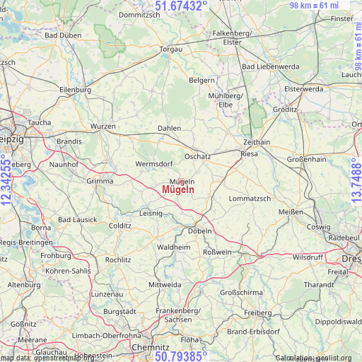
Mügeln GPS coordinates[2]
51° 14' 10.284" North, 13° 2' 44.412" East
| Map corner | latitude | longitude |
|---|---|---|
| Upper-left | 51.67432°, | 12.34255° |
| Center: | 51.23619°, | 13.04567° |
| Lower-right: | 50.79385°, | 13.7488° |
| Map W x H: | 97.9×97.9 km | = 60.8×60.8mi |
| max Lat: | 55.01917° ⇑37.9% North |
| Mügeln: | 51.23619° |
| min Lat: | ⇓62.1% South 47.40724° |
| min Long | Mügeln | max Long |
| 5.92978° | 13.04567° | 14.98853° |
| W 92.6%⇐ | ⇒7.4% E |
Elevation
Elevation of Mügeln is 150 m = 492 ft, and this is 99.1 m = 325 ft below average elevation for this country.
| Max E: |
1256 m = 4121 ft | 60.3% |
| Avg. | 249.1 m = 817 ft | |
| Mügeln | 150 m = 492 ft | |
Min E: |
-5 m = -16 ft | 39.7% |
See also: Germany elevation on elevation.city.
Geographical zone
Mügeln is located in North temperate zone (between Tropic of Cancer and the Arctic Circle). Distance of this North polar circle is 1704.2 km =1058.9 mi to North.| Distance of | km | miles | from Mügeln |
|---|---|---|---|
| North Pole | 4310.1 | 2678.2 | to North |
| Arctic Circle | 1704.2 | 1058.9 | to North |
| Tropic Cancer | 3091 | 1920.7 | to South |
| Equator | 5696.9 | 3539.9 | to South |


Nearby cities:
15 places around Mügeln: (largest is in red/bold)
• Bockelwitz
7.5 km =4.7 mi,  236°
236°
• Dahlen
14.7 km =9.1 mi,  347°
347°
• Döbeln
13.5 km =8.4 mi,  160°
160°
• Ebersbach
16 km =9.9 mi, 162°
• Gersdorf
15.7 km =9.8 mi,  208°
208°
• Großweitzschen
8.6 km =5.3 mi,  180°
180°
• Leisnig
12 km =7.5 mi,  223°
223°
• Mochau
14.9 km =9.3 mi,  140°
140°
• Mutzschen
11.1 km =6.9 mi,  284°
284°
• Naundorf
4.9 km =3 mi,  61°
61°
• Oschatz
8.4 km =5.2 mi,  32°
32°
• Ostrau
9.3 km =5.8 mi,  115°
115°
• Ostrau
11.7 km =7.3 mi,  253°
253°
• Stauchitz
11.8 km =7.3 mi,  86°
86°
• Wermsdorf
8.5 km =5.3 mi,  308°
308°
Sources, notices
• [Note1] Compared only with cities in Germany existing in our database
• [Src1] Map data: © OpenStreetMap contributors (CC-BY-SA)
• [Src2] Other city data from geonames.org with taken over terms of usage.
• [Src3] Geographical zone / Annual Mean Temperature by Robert A. Rohde @ Wikipedia
