Wermsdorf geodata
Wermsdorf (Saxony) is a seat of a fourth-order administrative division; located in Germany in Europe/Berlin (GMT+2) time zone. With population of 6,074 people, there are 2440 cities with bigger population in this country. Compared to other cities in Germany, 62.9% of cities are located further ↓South; 91.9% of cities are located further ←West and 56.3% of cities have higher elevation than Wermsdorf. Note1


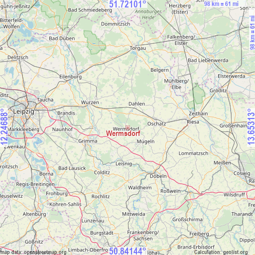
Wermsdorf GPS coordinates[2]
51° 16' 59.988" North, 12° 57' 0" East
| Map corner | latitude | longitude |
|---|---|---|
| Upper-left | 51.72101°, | 12.24688° |
| Center: | 51.28333°, | 12.95° |
| Lower-right: | 50.84144°, | 13.65313° |
| Map W x H: | 97.8×97.8 km | = 60.8×60.8mi |
| max Lat: | 55.01917° ⇑37.1% North |
| Wermsdorf: | 51.28333° |
| min Lat: | ⇓62.9% South 47.40724° |
| min Long | Wermsdorf | max Long |
| 5.92978° | 12.95° | 14.98853° |
| W 91.9%⇐ | ⇒8.1% E |
Elevation
Elevation of Wermsdorf is 179 m = 587 ft, and this is 70.1 m = 230 ft below average elevation for this country.
| Max E: |
1256 m = 4121 ft | 56.3% |
| Avg. | 249.1 m = 817 ft | |
| Wermsdorf | 179 m = 587 ft | |
Min E: |
-5 m = -16 ft | 43.7% |
See also: Germany elevation on elevation.city.
Geographical zone
Wermsdorf is located in North temperate zone (between Tropic of Cancer and the Arctic Circle). Distance of this North polar circle is 1699 km =1055.7 mi to North.| Distance of | km | miles | from Wermsdorf |
|---|---|---|---|
| North Pole | 4304.9 | 2674.9 | to North |
| Arctic Circle | 1699 | 1055.7 | to North |
| Tropic Cancer | 3096.3 | 1924 | to South |
| Equator | 5702.2 | 3543.2 | to South |


Nearby cities:
15 places around Wermsdorf: (largest is in red/bold)
• Bockelwitz
9.3 km =5.8 mi,  177°
177°
• Cavertitz
16.9 km =10.5 mi,  48°
48°
• Dahlen
9.7 km =6 mi,  20°
20°
• Falkenhain
14 km =8.7 mi,  336°
336°
• Grimma
17 km =10.6 mi,  250°
250°
• Großbothen
17.5 km =10.9 mi,  232°
232°
• Großweitzschen
15.4 km =9.6 mi,  154°
154°
• Leisnig
14.1 km =8.8 mi,  186°
186°
• Mutzschen
4.7 km =2.9 mi,  239°
239°
• Mügeln
8.5 km =5.3 mi,  128°
128°
• Naundorf
11.4 km =7.1 mi,  104°
104°
• Nerchau
11.3 km =7 mi,  262°
262°
• Oschatz
11.3 km =7 mi,  80°
80°
• Ostrau
9.7 km =6 mi,  208°
208°
• Trebsen
13.6 km =8.5 mi,  272°
272°
Sources, notices
• [Note1] Compared only with cities in Germany existing in our database
• [Src1] Map data: © OpenStreetMap contributors (CC-BY-SA)
• [Src2] Other city data from geonames.org with taken over terms of usage.
• [Src3] Geographical zone / Annual Mean Temperature by Robert A. Rohde @ Wikipedia
