Öchlitz geodata
Öchlitz (Saxony-Anhalt) is a populated place; located in Germany in Europe/Berlin (GMT+2) time zone. With population of 580 people, there are 8920 cities with bigger population in this country. Compared to other cities in Germany, 63.6% of cities are located further ↓South; 78.2% of cities are located further ←West and 60.6% of cities have higher elevation than Öchlitz. Note1


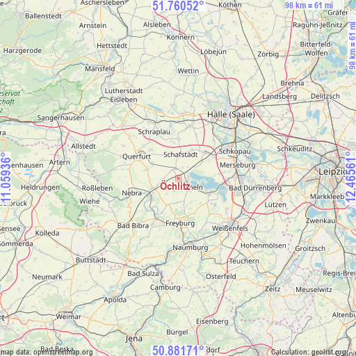
Öchlitz GPS coordinates[2]
51° 19' 23.592" North, 11° 45' 44.928" East
| Map corner | latitude | longitude |
|---|---|---|
| Upper-left | 51.76052°, | 11.05936° |
| Center: | 51.32322°, | 11.76248° |
| Lower-right: | 50.88171°, | 12.46561° |
| Map W x H: | 97.7×97.7 km | = 60.7×60.7mi |
| max Lat: | 55.01917° ⇑36.4% North |
| Öchlitz: | 51.32322° |
| min Lat: | ⇓63.6% South 47.40724° |
| min Long | Öchlitz | max Long |
| 5.92978° | 11.76248° | 14.98853° |
| W 78.2%⇐ | ⇒21.8% E |
Elevation
Elevation of Öchlitz is 148 m = 486 ft, and this is 101.1 m = 332 ft below average elevation for this country.
| Max E: |
1256 m = 4121 ft | 60.6% |
| Avg. | 249.1 m = 817 ft | |
| Öchlitz | 148 m = 486 ft | |
Min E: |
-5 m = -16 ft | 39.4% |
See also: Germany elevation on elevation.city.
Geographical zone
Öchlitz is located in North temperate zone (between Tropic of Cancer and the Arctic Circle). Distance of this North polar circle is 1694.6 km =1053 mi to North.| Distance of | km | miles | from Öchlitz |
|---|---|---|---|
| North Pole | 4300.5 | 2672.2 | to North |
| Arctic Circle | 1694.6 | 1053 | to North |
| Tropic Cancer | 3100.7 | 1926.7 | to South |
| Equator | 5706.6 | 3545.9 | to South |


Nearby cities:
15 places around Öchlitz: (largest is in red/bold)
• Bad Lauchstädt
10.2 km =6.3 mi,  46°
46°
• Barnstädt
9 km =5.6 mi,  284°
284°
• Braunsbedra
9.8 km =6.1 mi,  115°
115°
• Dornstedt
9.8 km =6.1 mi,  353°
353°
• Gleina
7.8 km =4.8 mi,  202°
202°
• Gröst
9.3 km =5.8 mi,  139°
139°
• Karsdorf
9.3 km =5.8 mi,  231°
231°
• Klobikau
5.8 km =3.6 mi,  58°
58°
• Krumpa
6.4 km =4 mi, 116°
• Langeneichstädt
2.8 km =1.7 mi,  331°
331°
• Mücheln
4.3 km =2.7 mi,  133°
133°
• Nemsdorf-Göhrendorf
8.4 km =5.2 mi,  290°
290°
• Schafstädt
6.5 km =4 mi,  6°
6°
• Steigra
7.1 km =4.4 mi,  248°
248°
• Steuden
10.7 km =6.6 mi,  1°
1°
Sources, notices
• [Note1] Compared only with cities in Germany existing in our database
• [Src1] Map data: © OpenStreetMap contributors (CC-BY-SA)
• [Src2] Other city data from geonames.org with taken over terms of usage.
• [Src3] Geographical zone / Annual Mean Temperature by Robert A. Rohde @ Wikipedia
