Schafstädt geodata
Schafstädt (Saxony-Anhalt) is a populated place; located in Germany in Europe/Berlin (GMT+2) time zone. With population of 2,170 people, there are 4847 cities with bigger population in this country. Compared to other cities in Germany, 64.4% of cities are located further ↓South; 78.4% of cities are located further ←West and 60.7% of cities have higher elevation than Schafstädt. Note1


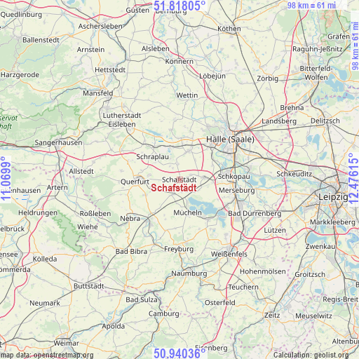
Schafstädt GPS coordinates[2]
51° 22' 52.716" North, 11° 46' 22.872" East
| Map corner | latitude | longitude |
|---|---|---|
| Upper-left | 51.81805°, | 11.0699° |
| Center: | 51.38131°, | 11.77302° |
| Lower-right: | 50.94036°, | 12.47615° |
| Map W x H: | 97.6×97.6 km | = 60.6×60.6mi |
| max Lat: | 55.01917° ⇑35.6% North |
| Schafstädt: | 51.38131° |
| min Lat: | ⇓64.4% South 47.40724° |
| min Long | Schafstädt | max Long |
| 5.92978° | 11.77302° | 14.98853° |
| W 78.4%⇐ | ⇒21.6% E |
Elevation
Elevation of Schafstädt is 147 m = 482 ft, and this is 102.1 m = 335 ft below average elevation for this country.
| Max E: |
1256 m = 4121 ft | 60.7% |
| Avg. | 249.1 m = 817 ft | |
| Schafstädt | 147 m = 482 ft | |
Min E: |
-5 m = -16 ft | 39.3% |
See also: Germany elevation on elevation.city.
Geographical zone
Schafstädt is located in North temperate zone (between Tropic of Cancer and the Arctic Circle). Distance of this North polar circle is 1688.1 km =1048.9 mi to North.| Distance of | km | miles | from Schafstädt |
|---|---|---|---|
| North Pole | 4294 | 2668.2 | to North |
| Arctic Circle | 1688.1 | 1048.9 | to North |
| Tropic Cancer | 3107.1 | 1930.7 | to South |
| Equator | 5713.1 | 3550 | to South |


Nearby cities:
15 places around Schafstädt: (largest is in red/bold)
• Bad Lauchstädt
6.7 km =4.2 mi,  85°
85°
• Delitz am Berge
9.7 km =6 mi,  65°
65°
• Dornstedt
3.8 km =2.4 mi,  330°
330°
• Esperstedt
8.1 km =5 mi,  305°
305°
• Klobikau
5.4 km =3.4 mi,  129°
129°
• Langeneichstädt
4.5 km =2.8 mi,  207°
207°
• Milzau
8.8 km =5.5 mi, 94°
• Nemsdorf-Göhrendorf
9.2 km =5.7 mi,  247°
247°
• Obhausen
8.4 km =5.2 mi,  277°
277°
• Schraplau
9.6 km =6 mi, 310°
• Stedten
8.8 km =5.5 mi,  321°
321°
• Steuden
4.2 km =2.6 mi,  353°
353°
• Teutschenthal
7.9 km =4.9 mi,  13°
13°
• Wansleben
8.9 km =5.5 mi, 350°
• Öchlitz
6.5 km =4 mi,  186°
186°
Sources, notices
• [Note1] Compared only with cities in Germany existing in our database
• [Src1] Map data: © OpenStreetMap contributors (CC-BY-SA)
• [Src2] Other city data from geonames.org with taken over terms of usage.
• [Src3] Geographical zone / Annual Mean Temperature by Robert A. Rohde @ Wikipedia
