Klobikau geodata
Klobikau (Saxony-Anhalt) is a populated place; located in Germany in Europe/Berlin (GMT+2) time zone. With population of 589 people, there are 8882 cities with bigger population in this country. Compared to other cities in Germany, 63.9% of cities are located further ↓South; 79.3% of cities are located further ←West and 64.8% of cities have higher elevation than Klobikau. Note1


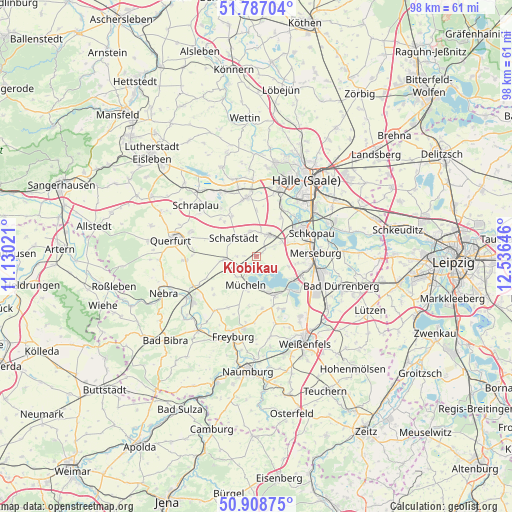
Klobikau GPS coordinates[2]
51° 21' 0" North, 11° 49' 59.988" East
| Map corner | latitude | longitude |
|---|---|---|
| Upper-left | 51.78704°, | 11.13021° |
| Center: | 51.35°, | 11.83333° |
| Lower-right: | 50.90875°, | 12.53646° |
| Map W x H: | 97.7×97.7 km | = 60.7×60.7mi |
| max Lat: | 55.01917° ⇑36.1% North |
| Klobikau: | 51.35° |
| min Lat: | ⇓63.9% South 47.40724° |
| min Long | Klobikau | max Long |
| 5.92978° | 11.83333° | 14.98853° |
| W 79.3%⇐ | ⇒20.7% E |
Elevation
Elevation of Klobikau is 121 m = 397 ft, and this is 128.1 m = 420 ft below average elevation for this country.
| Max E: |
1256 m = 4121 ft | 64.8% |
| Avg. | 249.1 m = 817 ft | |
| Klobikau | 121 m = 397 ft | |
Min E: |
-5 m = -16 ft | 35.2% |
See also: Germany elevation on elevation.city.
Geographical zone
Klobikau is located in North temperate zone (between Tropic of Cancer and the Arctic Circle). Distance of this North polar circle is 1691.6 km =1051.1 mi to North.| Distance of | km | miles | from Klobikau |
|---|---|---|---|
| North Pole | 4297.5 | 2670.3 | to North |
| Arctic Circle | 1691.6 | 1051.1 | to North |
| Tropic Cancer | 3103.7 | 1928.5 | to South |
| Equator | 5709.6 | 3547.8 | to South |


Nearby cities:
15 places around Klobikau: (largest is in red/bold)
• Bad Lauchstädt
4.8 km =3 mi,  31°
31°
• Beuna
8.9 km =5.5 mi,  114°
114°
• Braunsbedra
8.1 km =5 mi,  151°
151°
• Delitz am Berge
8.8 km =5.5 mi, 32°
• Dornstedt
9.1 km =5.7 mi,  318°
318°
• Frankleben
7.9 km =4.9 mi,  122°
122°
• Geusa
7.8 km =4.8 mi,  98°
98°
• Knapendorf
7.8 km =4.8 mi,  68°
68°
• Krumpa
5.9 km =3.7 mi,  172°
172°
• Langeneichstädt
6.3 km =3.9 mi,  265°
265°
• Milzau
5.3 km =3.3 mi,  58°
58°
• Mücheln
6.2 km =3.9 mi,  196°
196°
• Schafstädt
5.4 km =3.4 mi,  309°
309°
• Steuden
9 km =5.6 mi,  328°
328°
• Öchlitz
5.8 km =3.6 mi,  238°
238°
Sources, notices
• [Note1] Compared only with cities in Germany existing in our database
• [Src1] Map data: © OpenStreetMap contributors (CC-BY-SA)
• [Src2] Other city data from geonames.org with taken over terms of usage.
• [Src3] Geographical zone / Annual Mean Temperature by Robert A. Rohde @ Wikipedia
