Solnhofen geodata
Solnhofen (Bavaria) is a seat of a fourth-order administrative division; located in Germany in Europe/Berlin (GMT+2) time zone. With population of 1,817 people, there are 5320 cities with bigger population in this country. Compared to other cities in Germany, 84.1% of cities are located further ↑North; 66.9% of cities are located further ←West and 82.4% of cities have lower elevation than Solnhofen. Note1
Administrative division(s):
- Level 1: Bavaria
- Level 2: Regierungsbezirk Mittelfranken
- Level 3: Landkreis Weißenburg-Gunzenhausen
- Level 4: Solnhofen


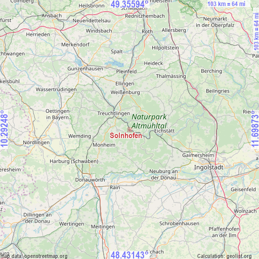
Solnhofen GPS coordinates[2]
48° 53' 44.952" North, 10° 59' 44.16" East
| Map corner | latitude | longitude |
|---|---|---|
| Upper-left | 49.35594°, | 10.29248° |
| Center: | 48.89582°, | 10.9956° |
| Lower-right: | 48.43143°, | 11.69873° |
| Map W x H: | 102.8×102.8 km | = 63.9×63.9mi |
| max Lat: | 55.01917° ⇑84.1% North |
| Solnhofen: | 48.89582° |
| min Lat: | ⇓15.9% South 47.40724° |
| min Long | Solnhofen | max Long |
| 5.92978° | 10.9956° | 14.98853° |
| W 66.9%⇐ | ⇒33.1% E |
Elevation
Elevation of Solnhofen is 449 m = 1473 ft, and this is 199.9 m = 656 ft above average elevation for this country.
| Max E: |
1256 m = 4121 ft | 17.6% |
| Solnhofen | 449 m 1473 ft | |
| Avg. | 249.1 m = 817 ft | |
Min E: |
-5 m = -16 ft | 82.4% |
See also: Germany elevation on elevation.city.
Geographical zone
Solnhofen is located in North temperate zone (between Tropic of Cancer and the Arctic Circle). Distance of this North polar circle is 1964.5 km =1220.7 mi to North.| Distance of | km | miles | from Solnhofen |
|---|---|---|---|
| North Pole | 4570.4 | 2839.9 | to North |
| Arctic Circle | 1964.5 | 1220.7 | to North |
| Tropic Cancer | 2830.8 | 1759 | to South |
| Equator | 5436.7 | 3378.2 | to South |


Nearby cities:
15 places around Solnhofen: (largest is in red/bold)
• Daiting
13.3 km =8.3 mi,  209°
209°
• Eichstätt
14.7 km =9.1 mi,  93°
93°
• Langenaltheim
4.7 km =2.9 mi,  266°
266°
• Monheim
11.6 km =7.2 mi,  240°
240°
• Otting
14.5 km =9 mi,  259°
259°
• Pappenheim
4.5 km =2.8 mi,  339°
339°
• Pollenfeld
16.1 km =10 mi,  68°
68°
• Raitenbuch
16.2 km =10.1 mi,  35°
35°
• Rennertshofen
15.6 km =9.7 mi,  166°
166°
• Rögling
6.1 km =3.8 mi, 213°
• Schernfeld
7.6 km =4.7 mi, 86°
• Tagmersheim
9.1 km =5.7 mi,  193°
193°
• Treuchtlingen
9.1 km =5.7 mi,  315°
315°
• Weißenburg in Bayern
15.1 km =9.4 mi,  353°
353°
• Wolferstadt
15.7 km =9.8 mi, 273°
Sources, notices
• [Note1] Compared only with cities in Germany existing in our database
• [Src1] Map data: © OpenStreetMap contributors (CC-BY-SA)
• [Src2] Other city data from geonames.org with taken over terms of usage.
• [Src3] Geographical zone / Annual Mean Temperature by Robert A. Rohde @ Wikipedia
