Cölpin geodata
Cölpin (Mecklenburg-Vorpommern) is a populated place; located in Germany in Europe/Berlin (GMT+2) time zone. With population of 806 people, there are 7871 cities with bigger population in this country. Compared to other cities in Germany, 85.8% of cities are located further ↓South; 95.4% of cities are located further ←West and 71.5% of cities have higher elevation than Cölpin. Note1
Administrative division(s):
- Level 1: Mecklenburg-Vorpommern
- Level 3: Mecklenburgische Seenplatte
- Level 4: Cölpin


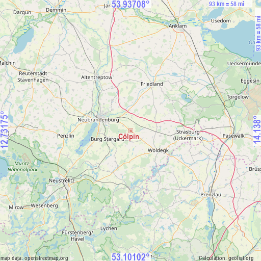
Cölpin GPS coordinates[2]
53° 31' 15.996" North, 13° 26' 5.532" East
| Map corner | latitude | longitude |
|---|---|---|
| Upper-left | 53.93708°, | 12.73175° |
| Center: | 53.52111°, | 13.43487° |
| Lower-right: | 53.10102°, | 14.138° |
| Map W x H: | 93×93 km | = 57.8×57.8mi |
| max Lat: | 55.01917° ⇑14.2% North |
| Cölpin: | 53.52111° |
| min Lat: | ⇓85.8% South 47.40724° |
| min Long | Cölpin | max Long |
| 5.92978° | 13.43487° | 14.98853° |
| W 95.4%⇐ | ⇒4.6% E |
Elevation
Elevation of Cölpin is 81 m = 266 ft, and this is 168.1 m = 552 ft below average elevation for this country.
| Max E: |
1256 m = 4121 ft | 71.5% |
| Avg. | 249.1 m = 817 ft | |
| Cölpin | 81 m = 266 ft | |
Min E: |
-5 m = -16 ft | 28.5% |
See also: Germany elevation on elevation.city.
Geographical zone
Cölpin is located in North temperate zone (between Tropic of Cancer and the Arctic Circle). Distance of this North polar circle is 1450.2 km =901.1 mi to North.| Distance of | km | miles | from Cölpin |
|---|---|---|---|
| North Pole | 4056.1 | 2520.3 | to North |
| Arctic Circle | 1450.2 | 901.1 | to North |
| Tropic Cancer | 3345.1 | 2078.5 | to South |
| Equator | 5951 | 3697.8 | to South |


Nearby cities:
15 places around Cölpin: (largest is in red/bold)
• Burg Stargard
8.6 km =5.3 mi,  251°
251°
• Eichhorst
9.2 km =5.7 mi,  26°
26°
• Groß Miltzow
10.6 km =6.6 mi,  81°
81°
• Holldorf
12.5 km =7.8 mi,  240°
240°
• Loitz
9.3 km =5.8 mi,  199°
199°
• Neubrandenburg
11.6 km =7.2 mi,  294°
294°
• Neuenkirchen
9.5 km =5.9 mi,  332°
332°
• Neverin
12.8 km =8 mi, 329°
• Pragsdorf
3.3 km =2.1 mi,  306°
306°
• Rossow
14.3 km =8.9 mi,  340°
340°
• Schönbeck
11.3 km =7 mi,  53°
53°
• Staven
12 km =7.5 mi,  350°
350°
• Teschendorf
8.7 km =5.4 mi,  215°
215°
• Trollenhagen
13.5 km =8.4 mi,  315°
315°
• Woldegk
11.9 km =7.4 mi,  124°
124°
Sources, notices
• [Note1] Compared only with cities in Germany existing in our database
• [Src1] Map data: © OpenStreetMap contributors (CC-BY-SA)
• [Src2] Other city data from geonames.org with taken over terms of usage.
• [Src3] Geographical zone / Annual Mean Temperature by Robert A. Rohde @ Wikipedia
