Rotenburg an der Fulda geodata
Rotenburg an der Fulda (Hesse) is a populated place; located in Germany in Europe/Berlin (GMT+2) time zone. With population of 14,271 people, there are 1112 cities with bigger population in this country. Compared to other cities in Germany, 58% of cities are located further ↓South; 53.9% of cities are located further →East and 55% of cities have higher elevation than Rotenburg an der Fulda. Note1
Administrative division(s):
- Level 1: Hesse
- Level 2: Regierungsbezirk Kassel
- Level 3: Landkreis Hersfeld-Rotenburg
- Level 4: Rotenburg a.d. Fulda


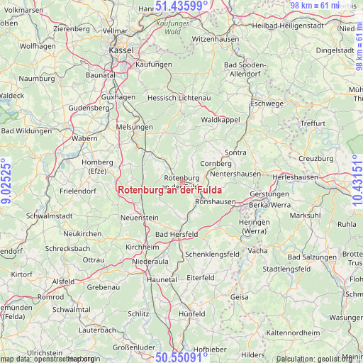
Rotenburg an der Fulda GPS coordinates[2]
50° 59' 44.016" North, 9° 43' 42.168" East
| Map corner | latitude | longitude |
|---|---|---|
| Upper-left | 51.43599°, | 9.02525° |
| Center: | 50.99556°, | 9.72838° |
| Lower-right: | 50.55091°, | 10.43151° |
| Map W x H: | 98.4×98.4 km | = 61.1×61.1mi |
| max Lat: | 55.01917° ⇑42% North |
| Rotenburg an der Fulda: | 50.99556° |
| min Lat: | ⇓58% South 47.40724° |
| min Long | Rotenburg an de | max Long |
| 5.92978° | 9.72838° | 14.98853° |
| W 46.1%⇐ | ⇒53.9% E |
Elevation
Elevation of Rotenburg an der Fulda is 188 m = 617 ft, and this is 61.1 m = 200 ft below average elevation for this country.
| Max E: |
1256 m = 4121 ft | 55% |
| Avg. | 249.1 m = 817 ft | |
| Rotenburg an der Fulda | 188 m = 617 ft | |
Min E: |
-5 m = -16 ft | 45% |
See also: Germany elevation on elevation.city.
Geographical zone
Rotenburg an der Fulda is located in North temperate zone (between Tropic of Cancer and the Arctic Circle). Distance of this North polar circle is 1731 km =1075.6 mi to North.| Distance of | km | miles | from Rotenburg an der Fulda |
|---|---|---|---|
| North Pole | 4336.9 | 2694.8 | to North |
| Arctic Circle | 1731 | 1075.6 | to North |
| Tropic Cancer | 3064.3 | 1904.1 | to South |
| Equator | 5670.2 | 3523.3 | to South |


Nearby cities:
15 places around Rotenburg an der Fulda: (largest is in red/bold)
• Alheim
6 km =3.7 mi,  314°
314°
• Bad Hersfeld
13.8 km =8.6 mi,  185°
185°
• Bebra
5.3 km =3.3 mi,  116°
116°
• Breitenbach
5.8 km =3.6 mi,  138°
138°
• Cornberg
10.6 km =6.6 mi,  61°
61°
• Friedewald
15.8 km =9.8 mi, 142°
• Großensee
18.1 km =11.2 mi,  112°
112°
• Kirchheim
21.3 km =13.2 mi,  212°
212°
• Malsfeld
17 km =10.6 mi, 308°
• Melsungen
19.4 km =12.1 mi,  320°
320°
• Nentershausen
14.5 km =9 mi,  80°
80°
• Ronshausen
9.9 km =6.2 mi, 120°
• Sontra
16.8 km =10.4 mi, 59°
• Spangenberg
14.2 km =8.8 mi,  341°
341°
• Waldkappel
19.6 km =12.2 mi,  32°
32°
Sources, notices
• [Note1] Compared only with cities in Germany existing in our database
• [Src1] Map data: © OpenStreetMap contributors (CC-BY-SA)
• [Src2] Other city data from geonames.org with taken over terms of usage.
• [Src3] Geographical zone / Annual Mean Temperature by Robert A. Rohde @ Wikipedia
