Neunkirchen am Potzberg geodata
Neunkirchen am Potzberg (Rheinland-Pfalz) is a seat of a fourth-order administrative division; located in Germany in Europe/Berlin (GMT+1) time zone. With population of 489 people, there are 9418 cities with bigger population in this country. Compared to other cities in Germany, 75.7% of cities are located further ↑North; 87.4% of cities are located further →East and 63.3% of cities have lower elevation than Neunkirchen am Potzberg. Note1
Administrative division(s):
- Level 1: Rheinland-Pfalz
- Level 3: Landkreis Kusel
- Level 4: Neunkirchen am Potzberg
Current local time in Neunkirchen am Potzberg:
03:27 PM, TuesdayDifference from your time zone: hours


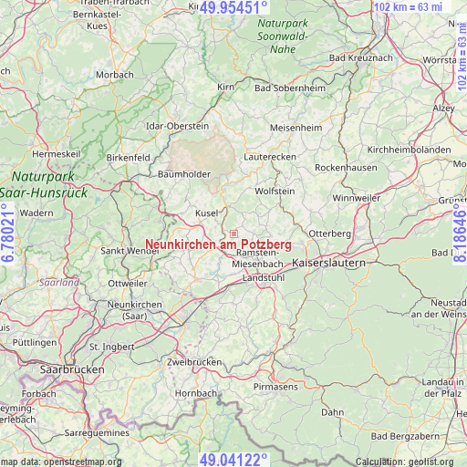
Neunkirchen am Potzberg GPS coordinates[2]
49° 30' 0" North, 7° 28' 59.988" East
| Map corner | latitude | longitude |
|---|---|---|
| Upper-left | 49.95451°, | 6.78021° |
| Center: | 49.5°, | 7.48333° |
| Lower-right: | 49.04122°, | 8.18646° |
| Map W x H: | 101.5×101.5 km | = 63.1×63.1mi |
| max Lat: | 55.01917° ⇑75.7% North |
| Neunkirchen am Potzberg: | 49.5° |
| min Lat: | ⇓24.3% South 47.40724° |
| min Long | Neunkirchen am | max Long |
| 5.92978° | 7.48333° | 14.98853° |
| W 12.6%⇐ | ⇒87.4% E |
Elevation
Elevation of Neunkirchen am Potzberg is 310 m = 1017 ft, and this is 60.9 m = 200 ft above average elevation for this country.
| Max E: |
1256 m = 4121 ft | 36.7% |
| Neunkirchen am Potzberg | 310 m 1017 ft | |
| Avg. | 249.1 m = 817 ft | |
Min E: |
-5 m = -16 ft | 63.3% |
See also: Germany elevation on elevation.city.
Geographical zone
Neunkirchen am Potzberg is located in North temperate zone (between Tropic of Cancer and the Arctic Circle). Distance of this North polar circle is 1897.3 km =1178.9 mi to North.| Distance of | km | miles | from Neunkirchen am Potzberg |
|---|---|---|---|
| North Pole | 4503.2 | 2798.2 | to North |
| Arctic Circle | 1897.3 | 1178.9 | to North |
| Tropic Cancer | 2898 | 1800.7 | to South |
| Equator | 5503.9 | 3420 | to South |


Nearby cities:
15 places around Neunkirchen am Potzberg: (largest is in red/bold)
• Bosenbach
5.6 km =3.5 mi,  37°
37°
• Etschberg
4.1 km =2.5 mi,  297°
297°
• Föckelberg
3.7 km =2.3 mi,  0°
0°
• Glan-Münchweiler
4.3 km =2.7 mi,  223°
223°
• Haschbach am Remigiusberg
5.2 km =3.2 mi,  315°
315°
• Kottweiler-Schwanden
4.1 km =2.5 mi,  117°
117°
• Matzenbach
1.2 km =0.7 mi,  270°
270°
• Niedermohr
4.7 km =2.9 mi,  192°
192°
• Niederstaufenbach
4.4 km =2.7 mi,  33°
33°
• Oberstaufenbach
2.6 km =1.6 mi,  47°
47°
• Quirnbach
5.3 km =3.3 mi,  238°
238°
• Rammelsbach
5.4 km =3.4 mi,  328°
328°
• Rehweiler
3.4 km =2.1 mi, 241°
• Reichenbach-Steegen
4.8 km =3 mi,  90°
90°
• Theisbergstegen
3.2 km =2 mi,  307°
307°
Sources, notices
• [Note1] Compared only with cities in Germany existing in our database
• [Src1] Map data: © OpenStreetMap contributors (CC-BY-SA)
• [Src2] Other city data from geonames.org with taken over terms of usage.
• [Src3] Geographical zone / Annual Mean Temperature by Robert A. Rohde @ Wikipedia
