Lupburg geodata
Lupburg (Bavaria) is a populated place; located in Germany in Europe/Berlin (GMT+2) time zone. With population of 2,336 people, there are 4622 cities with bigger population in this country. Compared to other cities in Germany, 81% of cities are located further ↑North; 78.2% of cities are located further ←West and 88.1% of cities have lower elevation than Lupburg. Note1
Administrative division(s):
- Level 1: Bavaria
- Level 2: Upper Palatinate
- Level 3: Landkreis Neumarkt in der Oberpfalz
- Level 4: Lupburg, Markt


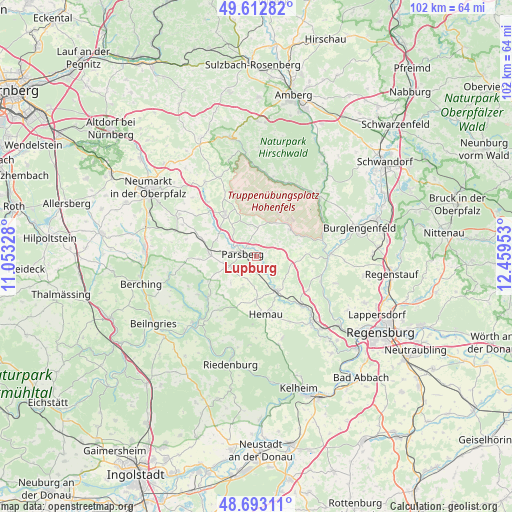
Lupburg GPS coordinates[2]
49° 9' 18.36" North, 11° 45' 23.04" East
| Map corner | latitude | longitude |
|---|---|---|
| Upper-left | 49.61282°, | 11.05328° |
| Center: | 49.1551°, | 11.7564° |
| Lower-right: | 48.69311°, | 12.45953° |
| Map W x H: | 102.3×102.3 km | = 63.6×63.6mi |
| max Lat: | 55.01917° ⇑81% North |
| Lupburg: | 49.1551° |
| min Lat: | ⇓19% South 47.40724° |
| min Long | Lupburg | max Long |
| 5.92978° | 11.7564° | 14.98853° |
| W 78.2%⇐ | ⇒21.8% E |
Elevation
Elevation of Lupburg is 495 m = 1624 ft, and this is 245.9 m = 807 ft above average elevation for this country.
| Max E: |
1256 m = 4121 ft | 11.9% |
| Lupburg | 495 m 1624 ft | |
| Avg. | 249.1 m = 817 ft | |
Min E: |
-5 m = -16 ft | 88.1% |
See also: Germany elevation on elevation.city.
Geographical zone
Lupburg is located in North temperate zone (between Tropic of Cancer and the Arctic Circle). Distance of this North polar circle is 1935.6 km =1202.7 mi to North.| Distance of | km | miles | from Lupburg |
|---|---|---|---|
| North Pole | 4541.5 | 2822 | to North |
| Arctic Circle | 1935.6 | 1202.7 | to North |
| Tropic Cancer | 2859.6 | 1776.9 | to South |
| Equator | 5465.5 | 3396.1 | to South |


Nearby cities:
15 places around Lupburg: (largest is in red/bold)
• Beratzhausen
7.7 km =4.8 mi,  149°
149°
• Brunn
12.1 km =7.5 mi,  120°
120°
• Deining
17.6 km =10.9 mi,  296°
296°
• Deuerling
17.3 km =10.7 mi,  139°
139°
• Duggendorf
12.4 km =7.7 mi,  110°
110°
• Hemau
11.4 km =7.1 mi,  170°
170°
• Hohenburg
15.9 km =9.9 mi,  11°
11°
• Hohenfels
8.6 km =5.3 mi,  50°
50°
• Kallmünz
14.9 km =9.3 mi,  87°
87°
• Parsberg
2.8 km =1.7 mi,  282°
282°
• Pielenhofen
17.3 km =10.7 mi, 122°
• Schmidmühlen
17.6 km =10.9 mi,  43°
43°
• Seubersdorf
9.4 km =5.8 mi,  274°
274°
• Velburg
10.6 km =6.6 mi,  324°
324°
• Wolfsegg
17 km =10.6 mi, 108°
Sources, notices
• [Note1] Compared only with cities in Germany existing in our database
• [Src1] Map data: © OpenStreetMap contributors (CC-BY-SA)
• [Src2] Other city data from geonames.org with taken over terms of usage.
• [Src3] Geographical zone / Annual Mean Temperature by Robert A. Rohde @ Wikipedia
