Hohenburg geodata
Hohenburg (Bavaria) is a populated place; located in Germany in Europe/Berlin (GMT+2) time zone. With population of 1,725 people, there are 5466 cities with bigger population in this country. Compared to other cities in Germany, 78.8% of cities are located further ↑North; 78.8% of cities are located further ←West and 73.5% of cities have lower elevation than Hohenburg. Note1
Administrative division(s):
- Level 1: Bavaria
- Level 2: Upper Palatinate
- Level 3: Landkreis Amberg-Sulzbach
- Level 4: Hohenburg, Markt


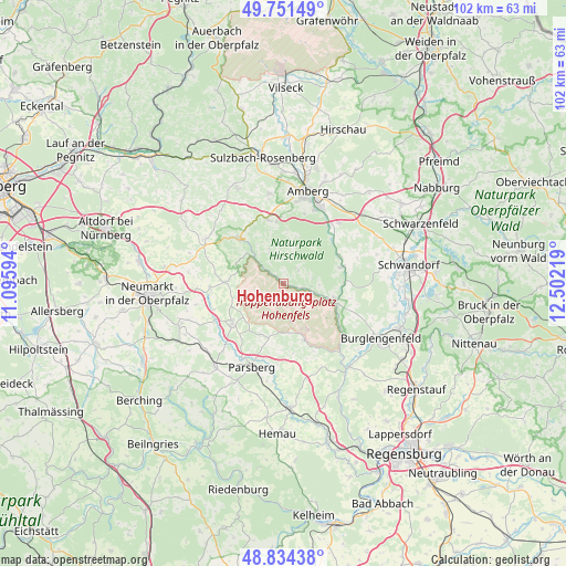
Hohenburg GPS coordinates[2]
49° 17' 42.252" North, 11° 47' 56.616" East
| Map corner | latitude | longitude |
|---|---|---|
| Upper-left | 49.75149°, | 11.09594° |
| Center: | 49.29507°, | 11.79906° |
| Lower-right: | 48.83438°, | 12.50219° |
| Map W x H: | 102×102 km | = 63.4×63.4mi |
| max Lat: | 55.01917° ⇑78.8% North |
| Hohenburg: | 49.29507° |
| min Lat: | ⇓21.2% South 47.40724° |
| min Long | Hohenburg | max Long |
| 5.92978° | 11.79906° | 14.98853° |
| W 78.8%⇐ | ⇒21.2% E |
Elevation
Elevation of Hohenburg is 386 m = 1266 ft, and this is 136.9 m = 449 ft above average elevation for this country.
| Max E: |
1256 m = 4121 ft | 26.5% |
| Hohenburg | 386 m 1266 ft | |
| Avg. | 249.1 m = 817 ft | |
Min E: |
-5 m = -16 ft | 73.5% |
See also: Germany elevation on elevation.city.
Geographical zone
Hohenburg is located in North temperate zone (between Tropic of Cancer and the Arctic Circle). Distance of this North polar circle is 1920.1 km =1193.1 mi to North.| Distance of | km | miles | from Hohenburg |
|---|---|---|---|
| North Pole | 4526 | 2812.3 | to North |
| Arctic Circle | 1920.1 | 1193.1 | to North |
| Tropic Cancer | 2875.2 | 1786.6 | to South |
| Equator | 5481.1 | 3405.8 | to South |


Nearby cities:
15 places around Hohenburg: (largest is in red/bold)
• Amberg
17.1 km =10.6 mi,  15°
15°
• Ammerthal
16.5 km =10.3 mi,  350°
350°
• Breitenbrunn
17.8 km =11.1 mi,  64°
64°
• Ebermannsdorf
14.8 km =9.2 mi,  42°
42°
• Ensdorf
11.1 km =6.9 mi, 62°
• Hohenfels
10.7 km =6.6 mi,  160°
160°
• Kastl
11.8 km =7.3 mi,  314°
314°
• Kümmersbruck
15.2 km =9.4 mi,  25°
25°
• Lauterhofen
16.4 km =10.2 mi,  299°
299°
• Lupburg
15.9 km =9.9 mi,  191°
191°
• Parsberg
16 km =9.9 mi,  201°
201°
• Rieden
10.8 km =6.7 mi,  72°
72°
• Schmidmühlen
9.5 km =5.9 mi,  107°
107°
• Ursensollen
12.3 km =7.6 mi,  344°
344°
• Velburg
11.6 km =7.2 mi,  232°
232°
Sources, notices
• [Note1] Compared only with cities in Germany existing in our database
• [Src1] Map data: © OpenStreetMap contributors (CC-BY-SA)
• [Src2] Other city data from geonames.org with taken over terms of usage.
• [Src3] Geographical zone / Annual Mean Temperature by Robert A. Rohde @ Wikipedia
