Brunn geodata
Brunn (Bavaria) is a seat of a fourth-order administrative division; located in Germany in Europe/Berlin (GMT+2) time zone. In our database, there are 11009 cities with bigger population. Compared to other cities in Germany, 81.7% of cities are located further ↑North; 80.3% of cities are located further ←West and 85% of cities have lower elevation than Brunn. Note1
Administrative division(s):
- Level 1: Bavaria
- Level 2: Upper Palatinate
- Level 3: Landkreis Regensburg
- Level 4: Brunn


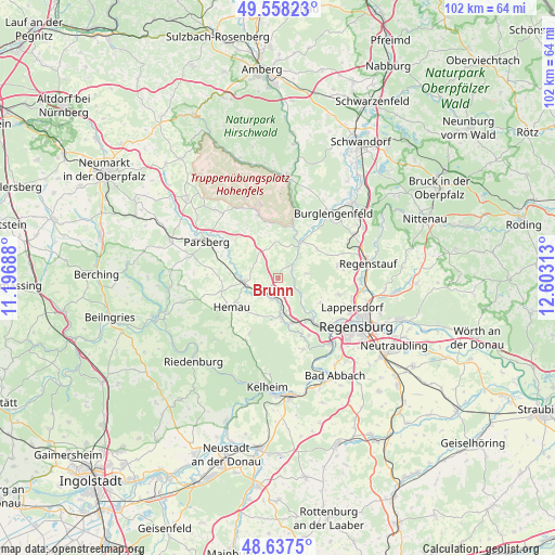
Brunn GPS coordinates[2]
49° 6' 0" North, 11° 54' 0" East
| Map corner | latitude | longitude |
|---|---|---|
| Upper-left | 49.55823°, | 11.19688° |
| Center: | 49.1°, | 11.9° |
| Lower-right: | 48.6375°, | 12.60313° |
| Map W x H: | 102.4×102.4 km | = 63.6×63.6mi |
| max Lat: | 55.01917° ⇑81.7% North |
| Brunn: | 49.1° |
| min Lat: | ⇓18.3% South 47.40724° |
| min Long | Brunn | max Long |
| 5.92978° | 11.9° | 14.98853° |
| W 80.3%⇐ | ⇒19.7% E |
Elevation
Elevation of Brunn is 469 m = 1539 ft, and this is 219.9 m = 721 ft above average elevation for this country.
| Max E: |
1256 m = 4121 ft | 15% |
| Brunn | 469 m 1539 ft | |
| Avg. | 249.1 m = 817 ft | |
Min E: |
-5 m = -16 ft | 85% |
See also: Germany elevation on elevation.city.
Geographical zone
Brunn is located in North temperate zone (between Tropic of Cancer and the Arctic Circle). Distance of this North polar circle is 1941.8 km =1206.6 mi to North.| Distance of | km | miles | from Brunn |
|---|---|---|---|
| North Pole | 4547.7 | 2825.8 | to North |
| Arctic Circle | 1941.8 | 1206.6 | to North |
| Tropic Cancer | 2853.5 | 1773.1 | to South |
| Equator | 5459.4 | 3392.3 | to South |


Nearby cities:
15 places around Brunn: (largest is in red/bold)
• Beratzhausen
6.6 km =4.1 mi,  265°
265°
• Deuerling
7 km =4.3 mi,  173°
173°
• Duggendorf
2.2 km =1.4 mi,  33°
33°
• Hemau
10 km =6.2 mi,  239°
239°
• Hohenfels
12.2 km =7.6 mi,  342°
342°
• Kallmünz
8.1 km =5 mi, 33°
• Lappersdorf
15.1 km =9.4 mi,  112°
112°
• Lupburg
12.1 km =7.5 mi,  300°
300°
• Nittendorf
9.5 km =5.9 mi,  151°
151°
• Painten
12.8 km =8 mi,  207°
207°
• Parsberg
14.8 km =9.2 mi, 297°
• Pettendorf
9 km =5.6 mi,  119°
119°
• Pielenhofen
5.2 km =3.2 mi,  126°
126°
• Sinzing
14.8 km =9.2 mi,  138°
138°
• Wolfsegg
5.7 km =3.5 mi,  81°
81°
Sources, notices
• [Note1] Compared only with cities in Germany existing in our database
• [Src1] Map data: © OpenStreetMap contributors (CC-BY-SA)
• [Src2] Other city data from geonames.org with taken over terms of usage.
• [Src3] Geographical zone / Annual Mean Temperature by Robert A. Rohde @ Wikipedia
