Kallmünz geodata
Kallmünz (Bavaria) is a populated place; located in Germany in Europe/Berlin (GMT+2) time zone. With population of 2,895 people, there are 4102 cities with bigger population in this country. Compared to other cities in Germany, 80.9% of cities are located further ↑North; 81.3% of cities are located further ←West and 68.6% of cities have lower elevation than Kallmünz. Note1
Administrative division(s):
- Level 1: Bavaria
- Level 2: Upper Palatinate
- Level 3: Landkreis Regensburg
- Level 4: Kallmünz, Markt


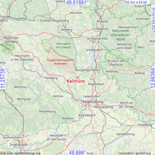
Kallmünz GPS coordinates[2]
49° 9' 39.384" North, 11° 57' 37.836" East
| Map corner | latitude | longitude |
|---|---|---|
| Upper-left | 49.61861°, | 11.25739° |
| Center: | 49.16094°, | 11.96051° |
| Lower-right: | 48.699°, | 12.66364° |
| Map W x H: | 102.3×102.2 km | = 63.6×63.5mi |
| max Lat: | 55.01917° ⇑80.9% North |
| Kallmünz: | 49.16094° |
| min Lat: | ⇓19.1% South 47.40724° |
| min Long | Kallmünz | max Long |
| 5.92978° | 11.96051° | 14.98853° |
| W 81.3%⇐ | ⇒18.7% E |
Elevation
Elevation of Kallmünz is 347 m = 1138 ft, and this is 97.9 m = 321 ft above average elevation for this country.
| Max E: |
1256 m = 4121 ft | 31.4% |
| Kallmünz | 347 m 1138 ft | |
| Avg. | 249.1 m = 817 ft | |
Min E: |
-5 m = -16 ft | 68.6% |
See also: Germany elevation on elevation.city.
Geographical zone
Kallmünz is located in North temperate zone (between Tropic of Cancer and the Arctic Circle). Distance of this North polar circle is 1935 km =1202.4 mi to North.| Distance of | km | miles | from Kallmünz |
|---|---|---|---|
| North Pole | 4540.9 | 2821.6 | to North |
| Arctic Circle | 1935 | 1202.4 | to North |
| Tropic Cancer | 2860.3 | 1777.3 | to South |
| Equator | 5466.2 | 3396.5 | to South |


Nearby cities:
15 places around Kallmünz: (largest is in red/bold)
• Beratzhausen
13.2 km =8.2 mi,  236°
236°
• Brunn
8.1 km =5 mi,  213°
213°
• Burglengenfeld
7.7 km =4.8 mi,  52°
52°
• Deuerling
14.2 km =8.8 mi,  194°
194°
• Duggendorf
5.9 km =3.7 mi, 212°
• Hohenfels
9.4 km =5.8 mi,  300°
300°
• Lupburg
14.9 km =9.3 mi,  267°
267°
• Maxhütte-Haidhof
10.5 km =6.5 mi,  65°
65°
• Pettendorf
11.7 km =7.3 mi,  162°
162°
• Pielenhofen
9.9 km =6.2 mi,  181°
181°
• Regenstauf
13.2 km =8.2 mi,  110°
110°
• Schmidmühlen
12.3 km =7.6 mi,  347°
347°
• Teublitz
11.5 km =7.1 mi, 53°
• Wolfsegg
6.1 km =3.8 mi,  167°
167°
• Zeitlarn
14.3 km =8.9 mi,  129°
129°
Sources, notices
• [Note1] Compared only with cities in Germany existing in our database
• [Src1] Map data: © OpenStreetMap contributors (CC-BY-SA)
• [Src2] Other city data from geonames.org with taken over terms of usage.
• [Src3] Geographical zone / Annual Mean Temperature by Robert A. Rohde @ Wikipedia
