Wolfsegg geodata
Wolfsegg (Bavaria) is a seat of a fourth-order administrative division; located in Germany in Europe/Berlin (GMT+2) time zone. With population of 1,506 people, there are 5869 cities with bigger population in this country. Compared to other cities in Germany, 81.6% of cities are located further ↑North; 81.5% of cities are located further ←West and 76.2% of cities have lower elevation than Wolfsegg. Note1
Administrative division(s):
- Level 1: Bavaria
- Level 2: Upper Palatinate
- Level 3: Landkreis Regensburg
- Level 4: Wolfsegg


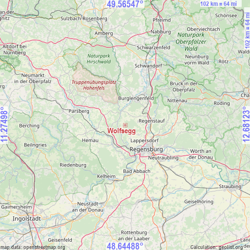
Wolfsegg GPS coordinates[2]
49° 6' 26.316" North, 11° 58' 41.16" East
| Map corner | latitude | longitude |
|---|---|---|
| Upper-left | 49.56547°, | 11.27498° |
| Center: | 49.10731°, | 11.9781° |
| Lower-right: | 48.64488°, | 12.68123° |
| Map W x H: | 102.4×102.4 km | = 63.6×63.6mi |
| max Lat: | 55.01917° ⇑81.6% North |
| Wolfsegg: | 49.10731° |
| min Lat: | ⇓18.4% South 47.40724° |
| min Long | Wolfsegg | max Long |
| 5.92978° | 11.9781° | 14.98853° |
| W 81.5%⇐ | ⇒18.5% E |
Elevation
Elevation of Wolfsegg is 407 m = 1335 ft, and this is 157.9 m = 518 ft above average elevation for this country.
| Max E: |
1256 m = 4121 ft | 23.8% |
| Wolfsegg | 407 m 1335 ft | |
| Avg. | 249.1 m = 817 ft | |
Min E: |
-5 m = -16 ft | 76.2% |
See also: Germany elevation on elevation.city.
Geographical zone
Wolfsegg is located in North temperate zone (between Tropic of Cancer and the Arctic Circle). Distance of this North polar circle is 1941 km =1206.1 mi to North.| Distance of | km | miles | from Wolfsegg |
|---|---|---|---|
| North Pole | 4546.8 | 2825.2 | to North |
| Arctic Circle | 1941 | 1206.1 | to North |
| Tropic Cancer | 2854.3 | 1773.6 | to South |
| Equator | 5460.2 | 3392.8 | to South |


Nearby cities:
15 places around Wolfsegg: (largest is in red/bold)
• Beratzhausen
12.3 km =7.6 mi,  263°
263°
• Brunn
5.7 km =3.5 mi, 261°
• Burglengenfeld
11.8 km =7.3 mi,  24°
24°
• Deuerling
9.2 km =5.7 mi,  212°
212°
• Duggendorf
4.6 km =2.9 mi,  283°
283°
• Kallmünz
6.1 km =3.8 mi,  347°
347°
• Lappersdorf
10.6 km =6.6 mi,  129°
129°
• Maxhütte-Haidhof
13.2 km =8.2 mi,  38°
38°
• Nittendorf
9.3 km =5.8 mi,  187°
187°
• Pettendorf
5.6 km =3.5 mi,  157°
157°
• Pielenhofen
4.2 km =2.6 mi,  201°
201°
• Regenstauf
11.2 km =7 mi,  82°
82°
• Reinhausen
13 km =8.1 mi, 130°
• Sinzing
12.6 km =7.8 mi, 161°
• Zeitlarn
10.2 km =6.3 mi,  108°
108°
Sources, notices
• [Note1] Compared only with cities in Germany existing in our database
• [Src1] Map data: © OpenStreetMap contributors (CC-BY-SA)
• [Src2] Other city data from geonames.org with taken over terms of usage.
• [Src3] Geographical zone / Annual Mean Temperature by Robert A. Rohde @ Wikipedia
