Schmidmühlen geodata
Schmidmühlen (Bavaria) is a populated place; located in Germany in Europe/Berlin (GMT+2) time zone. With population of 2,481 people, there are 4463 cities with bigger population in this country. Compared to other cities in Germany, 79.2% of cities are located further ↑North; 80.6% of cities are located further ←West and 70.5% of cities have lower elevation than Schmidmühlen. Note1
Administrative division(s):
- Level 1: Bavaria
- Level 2: Upper Palatinate
- Level 3: Landkreis Amberg-Sulzbach
- Level 4: Schmidmühlen, Markt


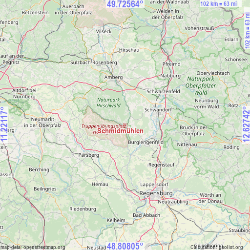
Schmidmühlen GPS coordinates[2]
49° 16' 8.328" North, 11° 55' 27.444" East
| Map corner | latitude | longitude |
|---|---|---|
| Upper-left | 49.72564°, | 11.22117° |
| Center: | 49.26898°, | 11.92429° |
| Lower-right: | 48.80805°, | 12.62742° |
| Map W x H: | 102×102 km | = 63.4×63.4mi |
| max Lat: | 55.01917° ⇑79.2% North |
| Schmidmühlen: | 49.26898° |
| min Lat: | ⇓20.8% South 47.40724° |
| min Long | Schmidmühlen | max Long |
| 5.92978° | 11.92429° | 14.98853° |
| W 80.6%⇐ | ⇒19.4% E |
Elevation
Elevation of Schmidmühlen is 362 m = 1188 ft, and this is 112.9 m = 370 ft above average elevation for this country.
| Max E: |
1256 m = 4121 ft | 29.5% |
| Schmidmühlen | 362 m 1188 ft | |
| Avg. | 249.1 m = 817 ft | |
Min E: |
-5 m = -16 ft | 70.5% |
See also: Germany elevation on elevation.city.
Geographical zone
Schmidmühlen is located in North temperate zone (between Tropic of Cancer and the Arctic Circle). Distance of this North polar circle is 1923 km =1194.9 mi to North.| Distance of | km | miles | from Schmidmühlen |
|---|---|---|---|
| North Pole | 4528.9 | 2814.1 | to North |
| Arctic Circle | 1923 | 1194.9 | to North |
| Tropic Cancer | 2872.3 | 1784.8 | to South |
| Equator | 5478.2 | 3404 | to South |


Nearby cities:
15 places around Schmidmühlen: (largest is in red/bold)
• Breitenbrunn
12.6 km =7.8 mi,  33°
33°
• Burglengenfeld
11.3 km =7 mi,  129°
129°
• Duggendorf
16.9 km =10.5 mi,  181°
181°
• Ebermannsdorf
13.9 km =8.6 mi,  3°
3°
• Ensdorf
8 km =5 mi,  6°
6°
• Hohenburg
9.5 km =5.9 mi,  287°
287°
• Hohenfels
9.1 km =5.7 mi,  217°
217°
• Holzheim bei Oder
17.6 km =10.9 mi,  90°
90°
• Kallmünz
12.3 km =7.6 mi,  167°
167°
• Kümmersbruck
16.9 km =10.5 mi,  351°
351°
• Lupburg
17.6 km =10.9 mi, 223°
• Maxhütte-Haidhof
14.4 km =8.9 mi,  122°
122°
• Rieden
6.2 km =3.9 mi, 11°
• Schwandorf in Bayern
14.8 km =9.2 mi,  65°
65°
• Teublitz
12.9 km =8 mi,  113°
113°
Sources, notices
• [Note1] Compared only with cities in Germany existing in our database
• [Src1] Map data: © OpenStreetMap contributors (CC-BY-SA)
• [Src2] Other city data from geonames.org with taken over terms of usage.
• [Src3] Geographical zone / Annual Mean Temperature by Robert A. Rohde @ Wikipedia
