Ludwigsstadt geodata
Ludwigsstadt (Bavaria) is a populated place; located in Germany in Europe/Berlin (GMT+2) time zone. With population of 3,790 people, there are 3411 cities with bigger population in this country. Compared to other cities in Germany, 53% of cities are located further ↑North; 72.5% of cities are located further ←West and 81.4% of cities have lower elevation than Ludwigsstadt. Note1
Administrative division(s):
- Level 1: Bavaria
- Level 2: Upper Franconia
- Level 3: Landkreis Kronach
- Level 4: Ludwigsstadt


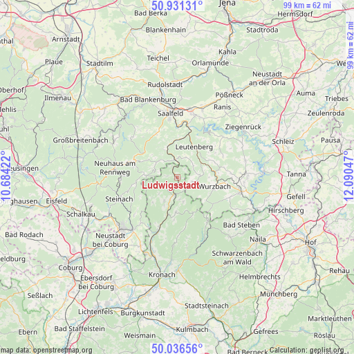
Ludwigsstadt GPS coordinates[2]
50° 29' 9.78" North, 11° 23' 14.424" East
| Map corner | latitude | longitude |
|---|---|---|
| Upper-left | 50.93131°, | 10.68422° |
| Center: | 50.48605°, | 11.38734° |
| Lower-right: | 50.03656°, | 12.09047° |
| Map W x H: | 99.5×99.5 km | = 61.8×61.8mi |
| max Lat: | 55.01917° ⇑53% North |
| Ludwigsstadt: | 50.48605° |
| min Lat: | ⇓47% South 47.40724° |
| min Long | Ludwigsstadt | max Long |
| 5.92978° | 11.38734° | 14.98853° |
| W 72.5%⇐ | ⇒27.5% E |
Elevation
Elevation of Ludwigsstadt is 443 m = 1453 ft, and this is 193.9 m = 636 ft above average elevation for this country.
| Max E: |
1256 m = 4121 ft | 18.6% |
| Ludwigsstadt | 443 m 1453 ft | |
| Avg. | 249.1 m = 817 ft | |
Min E: |
-5 m = -16 ft | 81.4% |
See also: Germany elevation on elevation.city.
Geographical zone
Ludwigsstadt is located in North temperate zone (between Tropic of Cancer and the Arctic Circle). Distance of this North polar circle is 1787.7 km =1110.8 mi to North.| Distance of | km | miles | from Ludwigsstadt |
|---|---|---|---|
| North Pole | 4393.5 | 2730 | to North |
| Arctic Circle | 1787.7 | 1110.8 | to North |
| Tropic Cancer | 3007.6 | 1868.8 | to South |
| Equator | 5613.5 | 3488.1 | to South |


Nearby cities:
15 places around Ludwigsstadt: (largest is in red/bold)
• Hohenwarte
14.4 km =8.9 mi,  28°
28°
• Kaulsdorf
14.9 km =9.3 mi,  12°
12°
• Leutenberg
9.9 km =6.2 mi, 29°
• Lichte
14.8 km =9.2 mi,  283°
283°
• Marktgölitz
8.6 km =5.3 mi,  334°
334°
• Nordhalben
15.2 km =9.4 mi,  145°
145°
• Piesau
12.5 km =7.8 mi,  285°
285°
• Probstzella
5.3 km =3.3 mi,  356°
356°
• Reichenbach
7.1 km =4.4 mi,  165°
165°
• Reichmannsdorf
11.6 km =7.2 mi,  307°
307°
• Schmiedefeld
13.2 km =8.2 mi, 293°
• Tettau
9.3 km =5.8 mi,  258°
258°
• Teuschnitz
9.8 km =6.1 mi,  182°
182°
• Tschirn
10.5 km =6.5 mi,  155°
155°
• Wurzbach
10.9 km =6.8 mi,  103°
103°
Sources, notices
• [Note1] Compared only with cities in Germany existing in our database
• [Src1] Map data: © OpenStreetMap contributors (CC-BY-SA)
• [Src2] Other city data from geonames.org with taken over terms of usage.
• [Src3] Geographical zone / Annual Mean Temperature by Robert A. Rohde @ Wikipedia
